IMAGES TAKEN NEAR TO
Stuart Street, INVERNESS, IV2 7QL
Introduction
This page details the photographs taken nearby to Stuart Street, IV2 7QL by members of the Geograph project.
The Geograph project started in 2005 with the aim of publishing, organising and preserving representative images for every square kilometre of Great Britain, Ireland and the Isle of Man.

There are currently over 7.5m images from over14,400 individuals and you can help contribute to the project by visiting https://www.geograph.org.uk
Image Map
Images are licensed for reuse under creativecommons.org/licenses/by-sa/2.0
Notes
- Clicking on the map will re-center to the selected point.
- The higher the marker number, the further away the image location is from the centre of the postcode.
Image Listing (86 Images Found)
Images are licensed for reuse under creativecommons.org/licenses/by-sa/2.0
Image
Details
Distance
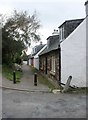

5
Former post office, High Street, Ardersier
The building has been empty for many years, and is currently up for sale together with the adjacent church [http://www.geograph.org.uk/photo/5929266]. It is likely to be demolished to allow for a future development.
Image: © Richard Sutcliffe
Taken: 29 Sep 2018
0.04 miles

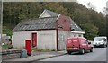
7
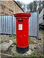
Postbox at Ardersier
IV2 54. Royal Mail list this box as 'Ardersier Post Office'.
Image: © David Bremner
Taken: 20 Nov 2022
0.05 miles
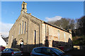
8

Former South United Free Church, High Street, Ardersier
Currently empty and up for sale. It has been on the Buildings at Risk Register since 2013 [https://www.buildingsatrisk.org.uk/details/935451].
Image: © Richard Sutcliffe
Taken: 29 Sep 2018
0.05 miles
9
Former Free Kirk
This kirk is no longer in ecclesiastical use and is for sale.
Image: © Anne Burgess
Taken: 26 Dec 2017
0.05 miles
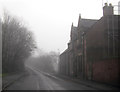
10
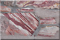
Detail of a Wall
The stones in the wall of a house in Station Road include these striped sandstones, the stripes being defined by the presence (red) or absence (white) of iron oxide. The largest stone has clearly been laid at an angle which, I am told, can cause differential erosion of the stone.
Image: © Anne Burgess
Taken: 26 Dec 2017
0.05 miles