IMAGES TAKEN NEAR TO
Bridgefield Gardens, IV2 7BN
Introduction
This page details the photographs taken nearby to Bridgefield Gardens, IV2 7BN by members of the Geograph project.
The Geograph project started in 2005 with the aim of publishing, organising and preserving representative images for every square kilometre of Great Britain, Ireland and the Isle of Man.

There are currently over 7.5m images from over14,400 individuals and you can help contribute to the project by visiting https://www.geograph.org.uk
Image Map
Images are licensed for reuse under creativecommons.org/licenses/by-sa/2.0
Notes
- Clicking on the map will re-center to the selected point.
- The higher the marker number, the further away the image location is from the centre of the postcode.
Image Listing (9 Images Found)
Images are licensed for reuse under creativecommons.org/licenses/by-sa/2.0
Image
Details
Distance
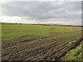
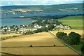
2
Arable at Ardersier
The old railway is prominent in the flat scene
Image: © Alan Reid
Taken: 25 Jul 2013
0.12 miles
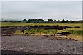
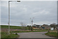
4
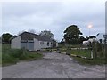
Milton of Connage
Barns and byres on the outskirts of the village of Ardersier.
Image: © Anne Burgess
Taken: 26 Dec 2017
0.19 miles
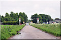
6
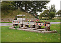
Wooden train, Ardersier
Wooden planters in the shape of a train, next to the B9006 and B9092. This is where the Fort George Branch crossed the road. The bridge is gone, but the embankment is still visible on the left.
Image: © Craig Wallace
Taken: 22 Sep 2020
0.23 miles
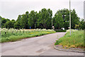
8
Ardersier : The B9092
A road heading out from Ardersier.
Image: © Lewis Clarke
Taken: 23 Apr 2016
0.24 miles
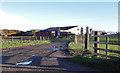
9
Yard and building at Ardersier Industrial Estate
These premises appear to be little used.
Image: © Alpin Stewart
Taken: 25 May 2016
0.25 miles