IMAGES TAKEN NEAR TO
Vallance Road, INVERNESS, IV2 7AE
Introduction
This page details the photographs taken nearby to Vallance Road, IV2 7AE by members of the Geograph project.
The Geograph project started in 2005 with the aim of publishing, organising and preserving representative images for every square kilometre of Great Britain, Ireland and the Isle of Man.

There are currently over 7.5m images from over14,400 individuals and you can help contribute to the project by visiting https://www.geograph.org.uk
Image Map
Images are licensed for reuse under creativecommons.org/licenses/by-sa/2.0
Notes
- Clicking on the map will re-center to the selected point.
- The higher the marker number, the further away the image location is from the centre of the postcode.
Image Listing (8 Images Found)
Images are licensed for reuse under creativecommons.org/licenses/by-sa/2.0
Image
Details
Distance
1
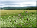
Agricultural Land Near Wester Kerrowgair
Image: © Mick Garratt
Taken: 16 Jun 2006
0.11 miles
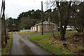
3
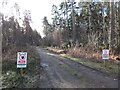
Overgrown track into forest near Dalcross
Image: © Steven Brown
Taken: 17 Aug 2010
0.14 miles
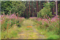
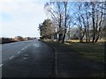
6
Telephone Box, B9039, Wester Kerrowgair
Image: © Mick Garratt
Taken: 16 Jun 2006
0.20 miles
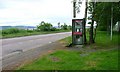
7
Bus stop and Telephone Box on B9039 at Wester Kerrowgair
Image: © Alpin Stewart
Taken: 21 Feb 2015
0.22 miles
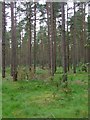
8
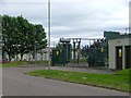
Sub Station, Airport Industrial Estate
Image: © Mick Garratt
Taken: 16 Jun 2006
0.22 miles