IMAGES TAKEN NEAR TO
LAIRG, IV27 4DN
Introduction
This page details the photographs taken nearby to IV27 4DN by members of the Geograph project.
The Geograph project started in 2005 with the aim of publishing, organising and preserving representative images for every square kilometre of Great Britain, Ireland and the Isle of Man.

There are currently over 7.5m images from over14,400 individuals and you can help contribute to the project by visiting https://www.geograph.org.uk
Image Map
Images are licensed for reuse under creativecommons.org/licenses/by-sa/2.0
Notes
- Clicking on the map will re-center to the selected point.
- The higher the marker number, the further away the image location is from the centre of the postcode.
Image Listing (6 Images Found)
Images are licensed for reuse under creativecommons.org/licenses/by-sa/2.0
Image
Details
Distance
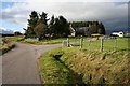
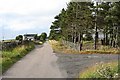
4
Junction of minor roads at Woodend Cottage
Looking south-westward.
Image: © Peter Wood
Taken: 5 Sep 2021
0.21 miles
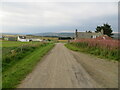
6
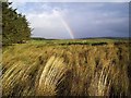
Croft Land And a Rainbow at Achfrish
Taken from the road.
Image: © Donald H Bain
Taken: 10 Nov 2005
0.24 miles