IMAGES TAKEN NEAR TO
Gorthleck, INVERNESS, IV2 6UL
Introduction
This page details the photographs taken nearby to IV2 6UL by members of the Geograph project.
The Geograph project started in 2005 with the aim of publishing, organising and preserving representative images for every square kilometre of Great Britain, Ireland and the Isle of Man.

There are currently over 7.5m images from over14,400 individuals and you can help contribute to the project by visiting https://www.geograph.org.uk
Image Map
Images are licensed for reuse under creativecommons.org/licenses/by-sa/2.0
Notes
- Clicking on the map will re-center to the selected point.
- The higher the marker number, the further away the image location is from the centre of the postcode.
Image Listing (6 Images Found)
Images are licensed for reuse under creativecommons.org/licenses/by-sa/2.0
Image
Details
Distance
1
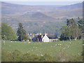
Corriegarth Lodge
New Wind Farm is to be built in coire tacked behind hills in background. Road to Wind farm can be seen leading up to fold in hills.
Image: © Sarah McGuire
Taken: 13 May 2008
0.01 miles
3
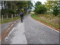
Along the road at Corriegarth
Riding out from a day in the Monadhliath hills above Loch Mhòr.
Image: © Richard Law
Taken: 21 Oct 2017
0.09 miles
5
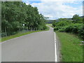
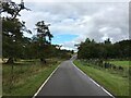
Minor road near to Corriegarth Lodge
Looking south-eastward,
The excellent condition of the road surface is no doubt the benefit of having a Wind Farm needing to use it for access.
Image: © Peter Wood
Taken: 4 Jul 2023
0.24 miles
6
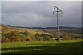
Cattle grazing in field
The sky in this picture looks threatening, which was very typical of the sunshine and showers weather of the day.
Image: © Fractal Angel
Taken: 16 Oct 2007
0.24 miles