IMAGES TAKEN NEAR TO
Greenwood Place, INVERNESS, IV2 6GN
Introduction
This page details the photographs taken nearby to Greenwood Place, IV2 6GN by members of the Geograph project.
The Geograph project started in 2005 with the aim of publishing, organising and preserving representative images for every square kilometre of Great Britain, Ireland and the Isle of Man.

There are currently over 7.5m images from over14,400 individuals and you can help contribute to the project by visiting https://www.geograph.org.uk
Image Map
Images are licensed for reuse under creativecommons.org/licenses/by-sa/2.0
Notes
- Clicking on the map will re-center to the selected point.
- The higher the marker number, the further away the image location is from the centre of the postcode.
Image Listing (6 Images Found)
Images are licensed for reuse under creativecommons.org/licenses/by-sa/2.0
Image
Details
Distance
1
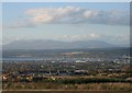
Looking over Inverness to Ben Wyvis
Taken from the outskirts of Castleton Village
Image: © Hill Walker
Taken: 31 Oct 2005
0.06 miles
2
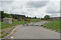
Road into a new housing development at Milton of Leys
Image: © Steven Brown
Taken: 28 May 2010
0.10 miles
3
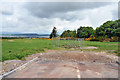
Field and the edge of Balvonie Wood near Inshes
Image: © Steven Brown
Taken: 28 May 2010
0.14 miles
4
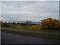
Industrial site at Milton of Leys, Inverness
Image: © Douglas Nelson
Taken: 13 Jun 2018
0.14 miles
5
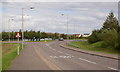
Roundabout, Milton of Leys
One of several roundabouts on the main road up through Milton of Leys.
Image: © Craig Wallace
Taken: 26 Sep 2019
0.24 miles
6
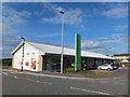
Co-operative Supermarket at Milton of Leys
Image: © Alpin Stewart
Taken: 30 Jul 2015
0.25 miles