IMAGES TAKEN NEAR TO
Brodie Road, IV2 6FX
Introduction
This page details the photographs taken nearby to Brodie Road, IV2 6FX by members of the Geograph project.
The Geograph project started in 2005 with the aim of publishing, organising and preserving representative images for every square kilometre of Great Britain, Ireland and the Isle of Man.

There are currently over 7.5m images from over14,400 individuals and you can help contribute to the project by visiting https://www.geograph.org.uk
Image Map (Loading...)


Getting Data...Please wait
Leaflet Map data © OpenStreetMap
Images are licensed for reuse under creativecommons.org/licenses/by-sa/2.0
Notes
- Clicking on the map will re-center to the selected point.
- The higher the marker number, the further away the image location is from the centre of the postcode.
Image Listing (3 Images Found)
Images are licensed for reuse under creativecommons.org/licenses/by-sa/2.0
Image
Details
Distance
3
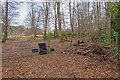
Fly Tipping
Since local councils no longer accept tyres at their recycling centres, fly-tipping has become a problem. Here 13 car tyres and other rubbish have been illegally dumped by the side of the quiet road to Ness Castle
Image: © valenta
Taken: 16 Mar 2020
0.21 miles