IMAGES TAKEN NEAR TO
Atholl Place, INVERNESS, IV2 6EX
Introduction
This page details the photographs taken nearby to Atholl Place, IV2 6EX by members of the Geograph project.
The Geograph project started in 2005 with the aim of publishing, organising and preserving representative images for every square kilometre of Great Britain, Ireland and the Isle of Man.

There are currently over 7.5m images from over14,400 individuals and you can help contribute to the project by visiting https://www.geograph.org.uk
Image Map
Images are licensed for reuse under creativecommons.org/licenses/by-sa/2.0
Notes
- Clicking on the map will re-center to the selected point.
- The higher the marker number, the further away the image location is from the centre of the postcode.
Image Listing (23 Images Found)
Images are licensed for reuse under creativecommons.org/licenses/by-sa/2.0
Image
Details
Distance
1
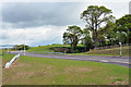
New road linking Milton of Leys to Inshes
Image: © Steven Brown
Taken: 28 May 2010
0.06 miles
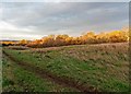
2
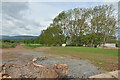
Part of the cleared land ready for development at Inshes
Image: © Steven Brown
Taken: 28 May 2010
0.08 miles
3
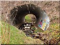
The Mill Burn
The Mill Burn where it runs under the new Milton of Leys link road
Image: © valenta
Taken: 8 Nov 2018
0.09 miles
4

The Mill Burn
The picturesque Mill Burn is hemmed in by the new housing schemes in Milton of Leys on its west bank. And it is only a question of time before the land to the east is built on
Image: © valenta
Taken: 8 Nov 2018
0.11 miles
5

The Mill Burn
The picturesque Mill Burn runs through a small gorge, hemmed in by new housing on its west bank in Milton of Leys
Image: © valenta
Taken: 8 Nov 2018
0.12 miles
6
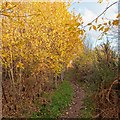
Milton of Leys
This path runs above the Mill Burn in an area of Milton of Leys that still, as yet, remains undeveloped.
Image: © valenta
Taken: 8 Nov 2018
0.12 miles
7
Prime housing land at Milton of Leys
This area of woodland and rough grassland is waiting for redevelopment in the sprawling Milton of Leys housing scheme to the south of Inverness City
Image: © valenta
Taken: 8 Nov 2018
0.13 miles
8
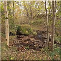
The Mill Burn
Erratic boulder, just downstream of the waterfall on the Mill Burn
Image: © valenta
Taken: 8 Nov 2018
0.14 miles
9
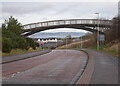
Bridge over Inshes Road
A path linking two sections of Inshes Park.
Image: © Craig Wallace
Taken: 30 Dec 2021
0.15 miles
10
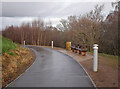
New path, Inshes Park
A new path and benches, in the third phase of Inshes Park. It is a smooth tarmac path, for pedestrians and cyclists, linking Elmwood Avenue to the bridge over Inshes Road.
Image: © Craig Wallace
Taken: 30 Dec 2021
0.15 miles