IMAGES TAKEN NEAR TO
Caulfield Avenue, INVERNESS, IV2 5GA
Introduction
This page details the photographs taken nearby to Caulfield Avenue, IV2 5GA by members of the Geograph project.
The Geograph project started in 2005 with the aim of publishing, organising and preserving representative images for every square kilometre of Great Britain, Ireland and the Isle of Man.

There are currently over 7.5m images from over14,400 individuals and you can help contribute to the project by visiting https://www.geograph.org.uk
Image Map
Images are licensed for reuse under creativecommons.org/licenses/by-sa/2.0
Notes
- Clicking on the map will re-center to the selected point.
- The higher the marker number, the further away the image location is from the centre of the postcode.
Image Listing (8 Images Found)
Images are licensed for reuse under creativecommons.org/licenses/by-sa/2.0
Image
Details
Distance
1
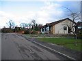
Cradlehall
Housing on Caulfield Terrace.
Image: © John Allan
Taken: 20 Feb 2007
0.08 miles
2
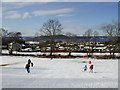
A snowy Maxwell Park looking over Cradlehall to the Black Isle
Image: © Donald Macleod
Taken: Unknown
0.09 miles
4
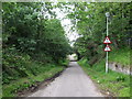
Bridge over national cycle network route 1
This road forms part of the national cycle network route 1 and it is closed to vehicles under the railway bridge.
Image: © don cload
Taken: 25 Jul 2010
0.23 miles
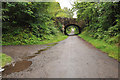
5
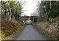
Resaurie Bridge, Caulfield Road North
The Highland Main Line railway crosses over this road. The road is blocked by bollards beneath the bridge, so it is passable by bicycle or motorcycle, but not cars.
Image: © Craig Wallace
Taken: 9 Apr 2021
0.24 miles
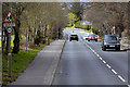
6
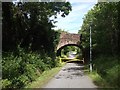
Caulfield Road North
The road is gated under the railway bridge, but still a good through route if not motorised.
Image: © Richard Webb
Taken: 4 Aug 2015
0.24 miles