IMAGES TAKEN NEAR TO
Culloden Moor, INVERNESS, IV2 5EG
Introduction
This page details the photographs taken nearby to IV2 5EG by members of the Geograph project.
The Geograph project started in 2005 with the aim of publishing, organising and preserving representative images for every square kilometre of Great Britain, Ireland and the Isle of Man.

There are currently over 7.5m images from over14,400 individuals and you can help contribute to the project by visiting https://www.geograph.org.uk
Image Map
Images are licensed for reuse under creativecommons.org/licenses/by-sa/2.0
Notes
- Clicking on the map will re-center to the selected point.
- The higher the marker number, the further away the image location is from the centre of the postcode.
Image Listing (5 Images Found)
Images are licensed for reuse under creativecommons.org/licenses/by-sa/2.0
Image
Details
Distance
1
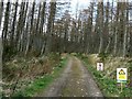
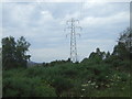
Culloden Forest
Track leading north from the B9006 into the forest.
Image: © James Allan
Taken: 12 Mar 2007
0.13 miles
2
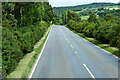
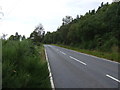
A bend in the B9006
Heading south west towards Inverness.
Image: © JThomas
Taken: 19 Jul 2014
0.16 miles
3
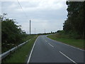
B9006 heading south west
Towards Inverness.
Image: © JThomas
Taken: 19 Jul 2014
0.18 miles