IMAGES TAKEN NEAR TO
Whiteface, DORNOCH, IV25 3RJ
Introduction
This page details the photographs taken nearby to IV25 3RJ by members of the Geograph project.
The Geograph project started in 2005 with the aim of publishing, organising and preserving representative images for every square kilometre of Great Britain, Ireland and the Isle of Man.

There are currently over 7.5m images from over14,400 individuals and you can help contribute to the project by visiting https://www.geograph.org.uk
Image Map
Images are licensed for reuse under creativecommons.org/licenses/by-sa/2.0
Notes
- Clicking on the map will re-center to the selected point.
- The higher the marker number, the further away the image location is from the centre of the postcode.
Image Listing (12 Images Found)
Images are licensed for reuse under creativecommons.org/licenses/by-sa/2.0
Image
Details
Distance
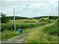
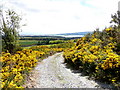
1
A wet track above Whiteface
Looking back towards the Dornoch Firth
Image: © sylvia duckworth
Taken: 19 Feb 2009
0.05 miles

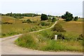
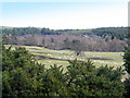
3
Track above Whiteface
Looking over the Dornoch Firth.
Image: © sylvia duckworth
Taken: 20 May 2011
0.13 miles
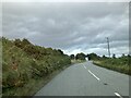
5

A949, Whiteface
Heading west towards Bonar Bridge.
Image: © JThomas
Taken: 8 May 2014
0.16 miles
6
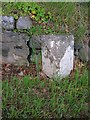
Old Milestone by the A949, Whiteface, Dornoch parish
Milestone by the A949, in parish of Dornoch (Sutherland District), near lane to Newton Point, on verge by wall.
Inscription once read:-
: (The Ord / 37) : : (Bonarbridge / 7) :
Surveyed
Milestone Society National ID: HI_BBWK07
Image: © Milestone Society
Taken: Unknown
0.20 miles