IMAGES TAKEN NEAR TO
Clashmore, DORNOCH, IV25 3RH
Introduction
This page details the photographs taken nearby to IV25 3RH by members of the Geograph project.
The Geograph project started in 2005 with the aim of publishing, organising and preserving representative images for every square kilometre of Great Britain, Ireland and the Isle of Man.

There are currently over 7.5m images from over14,400 individuals and you can help contribute to the project by visiting https://www.geograph.org.uk
Image Map
Images are licensed for reuse under creativecommons.org/licenses/by-sa/2.0
Notes
- Clicking on the map will re-center to the selected point.
- The higher the marker number, the further away the image location is from the centre of the postcode.
Image Listing (4 Images Found)
Images are licensed for reuse under creativecommons.org/licenses/by-sa/2.0
Image
Details
Distance
1
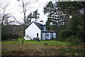
The Gamekeeper's Cottage
The cottage is part of the Ospisdale Estate in the Bardnabeinne area. Ospisdale Organic Farm has the only farmhouse on the estate.
Image: © Graeme Smith
Taken: 4 Jan 2008
0.03 miles
2
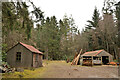
Forestry Sheds at Bardnabeinne, Sutherland
Image: © Andrew Tryon
Taken: 27 Mar 2021
0.04 miles
3
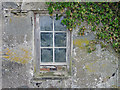
Overwhelmed farm building
The building is almost alive with the trees and shrubs encircling and entwining it. This side at least shows some intact building!
Image: © Julian Paren
Taken: 16 Mar 2013
0.15 miles
4
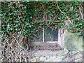
Overwhelmed farm building
The window paired with this one was utterly blocked by vegetation.
Image: © Julian Paren
Taken: 16 Mar 2013
0.15 miles