IMAGES TAKEN NEAR TO
Hilton, DORNOCH, IV25 3PW
Introduction
This page details the photographs taken nearby to IV25 3PW by members of the Geograph project.
The Geograph project started in 2005 with the aim of publishing, organising and preserving representative images for every square kilometre of Great Britain, Ireland and the Isle of Man.

There are currently over 7.5m images from over14,400 individuals and you can help contribute to the project by visiting https://www.geograph.org.uk
Image Map (10 Images)


Getting Data...Please wait
Leaflet Map data © OpenStreetMap
Images are licensed for reuse under creativecommons.org/licenses/by-sa/2.0
Notes
- Clicking on the map will re-center to the selected point.
- The higher the marker number, the further away the image location is from the centre of the postcode.
Image Listing (10 Images Found)
Images are licensed for reuse under creativecommons.org/licenses/by-sa/2.0
Image
Details
Distance
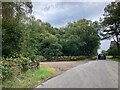
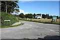
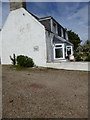
1
First house on Embo Street by junction
Image: © Sarah McGuire
Taken: 9 Oct 2009
0.01 miles
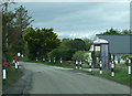
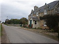
6
Sheep grazing near Embo Street junction
Image: © Sarah McGuire
Taken: 9 Oct 2009
0.17 miles
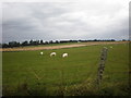
7
Field at Embo, Dornoch
Harvest has been brought in. Dornoch Firth in the background
Image: © Richard Kay
Taken: 21 Sep 2022
0.20 miles
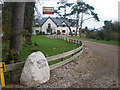
8

Round Glass roofed building on Embo Street.
Image: © Sarah McGuire
Taken: 9 Oct 2009
0.22 miles
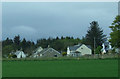
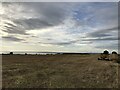
9
Hilton of Embo
The compact gravel drive of High Croft B&B supports the rare Crassula tillaea (showing red in the centre of the picture)
Image: © Mick Crawley
Taken: 11 Jun 2015
0.22 miles