IMAGES TAKEN NEAR TO
View Place, INVERNESS, IV2 4SA
Introduction
This page details the photographs taken nearby to View Place, IV2 4SA by members of the Geograph project.
The Geograph project started in 2005 with the aim of publishing, organising and preserving representative images for every square kilometre of Great Britain, Ireland and the Isle of Man.

There are currently over 7.5m images from over14,400 individuals and you can help contribute to the project by visiting https://www.geograph.org.uk
Image Map
Images are licensed for reuse under creativecommons.org/licenses/by-sa/2.0
Notes
- Clicking on the map will re-center to the selected point.
- The higher the marker number, the further away the image location is from the centre of the postcode.
Image Listing (640 Images Found)
Images are licensed for reuse under creativecommons.org/licenses/by-sa/2.0
Image
Details
Distance
2
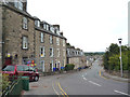
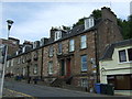
Culduthel Road - Inverness
Looking towards Inverness Castle, with Inverness Student Hostel on the left
Image: © valenta
Taken: 25 Feb 2018
0.01 miles
4
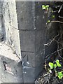
OS Cut Mark, Inverness, #1 Culduthel Road
Cut Mark on number 1 Culduthel Road
Image: © thejackrustles
Taken: 22 Jul 2015
0.02 miles
6
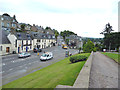
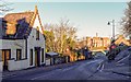
Inverness: Castle Street and road junction
Image: © Dr Neil Clifton
Taken: 4 Sep 2013
0.02 miles
8
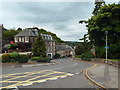
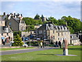
View Place, Inverness
View Place, photographed from the entrance gate to Inverness Castle.
Image: © Malc McDonald
Taken: 22 Jun 2015
0.02 miles
9
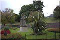
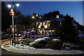
Faith, Hope and Charity, opposite Ness Bank church
Image: © Robert Eva
Taken: 22 Sep 2018
0.02 miles
10
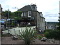
Castle Inn
Used to be named The Harlequin. This pub is right next to Inverness Castle
Image: © rich cressman
Taken: 15 May 2003
0.03 miles