IMAGES TAKEN NEAR TO
Culduthel Road, INVERNESS, IV2 4HH
Introduction
This page details the photographs taken nearby to Culduthel Road, IV2 4HH by members of the Geograph project.
The Geograph project started in 2005 with the aim of publishing, organising and preserving representative images for every square kilometre of Great Britain, Ireland and the Isle of Man.

There are currently over 7.5m images from over14,400 individuals and you can help contribute to the project by visiting https://www.geograph.org.uk
Image Map
Images are licensed for reuse under creativecommons.org/licenses/by-sa/2.0
Notes
- Clicking on the map will re-center to the selected point.
- The higher the marker number, the further away the image location is from the centre of the postcode.
Image Listing (18 Images Found)
Images are licensed for reuse under creativecommons.org/licenses/by-sa/2.0
Image
Details
Distance
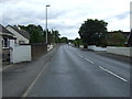
4
Inverness half marathon, on Burn Road
After heading up Culduthel Road, the half marathon route turns onto Burn Road, a minor road linking to Drummond Road. This is about 11.5 km into the race.
Image: © Craig Wallace
Taken: 12 Mar 2017
0.12 miles
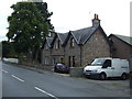
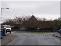
5
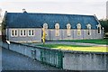
Hilton Church, Inverness
Built in the 1950's to serve the housing expansion in the town after the war. A thriving lively church.
Image: © Derek Brown
Taken: 3 Nov 2006
0.14 miles
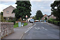
6
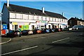
Row of shops Hilton, Inverness
Directly opposite image Image
Image: © Derek Brown
Taken: 3 Nov 2006
0.14 miles
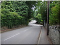
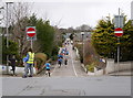
8
Culduthel Road continues on through Hilton
Heading to the centre of Inverness.
Image: © James Denham
Taken: 2 Sep 2013
0.17 miles
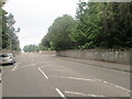
10
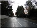
Culduthel Road, Inverness
Approaching the junction of Drummond Road and Muirfield Road.
Image: © Douglas Nelson
Taken: 26 Nov 2017
0.19 miles