IMAGES TAKEN NEAR TO
ARDGAY, IV24 3DL
Introduction
This page details the photographs taken nearby to IV24 3DL by members of the Geograph project.
The Geograph project started in 2005 with the aim of publishing, organising and preserving representative images for every square kilometre of Great Britain, Ireland and the Isle of Man.

There are currently over 7.5m images from over14,400 individuals and you can help contribute to the project by visiting https://www.geograph.org.uk
Image Map
Images are licensed for reuse under creativecommons.org/licenses/by-sa/2.0
Notes
- Clicking on the map will re-center to the selected point.
- The higher the marker number, the further away the image location is from the centre of the postcode.
Image Listing (24 Images Found)
Images are licensed for reuse under creativecommons.org/licenses/by-sa/2.0
Image
Details
Distance
3
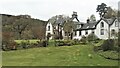
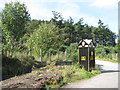
Cottage courtyard at the gate to Fearn Lodge
Image: © sylvia duckworth
Taken: 23 Sep 2011
0.12 miles
4
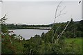
A View Point from the A836 Tain to Ardgay Road
Taken from a very handy layby and looking down towards the wee Loch cut off by the Railway that cuts across between NH6487 and NH6387
A good place for Swans and Ducks.
Image: © Donald H Bain
Taken: 5 Sep 2006
0.12 miles
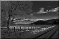
5
Railway running from Easter Fearn Point to Wester Fearn Point.
This is quite a feat of engineering considering the surrounding land mass.
Image: © Des Colhoun
Taken: 3 Sep 2006
0.12 miles
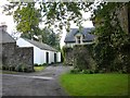
6
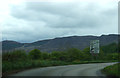
A bend in the A836
Heading east towards Tain.
Image: © JThomas
Taken: 8 May 2014
0.12 miles
7
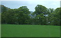
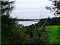
Grazing and woodland off the A836
Towards the Dornoch Firth.
Image: © JThomas
Taken: 8 May 2014
0.17 miles
9
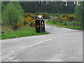
AA Box 504 - Ardgay
A Grade-B listed building - from Canmore http://canmore.org.uk/site/107755/ardgay-mid-fearn-aa-sentry-box-504 'This post-1957 standard Automobile Association motoring timber call box is located at the junction of the A9 and the A836 north of Struie Wood. One of only 7 surviving in Scotland, these served several purposes including acting as a shelter for AA officers and as part of the road-users safety network, especially after the installation of telephones (finally disconnected 2002).' This description is, however, now incorrect as the junction is with the B9176, and the closest the A9 gets is 12km to the east, where it crosses the Dornoch Firth west of Tain.
Image: © M J Richardson
Taken: 10 Sep 2015
0.21 miles
10
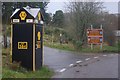
Ardgay AA Box
This beautifully preserved AA box stands at the junction of the A836 and the B9176 - although until the bridge over the Dornoch Firth was built what is now the A836 was the A9 and the B9176 was the A836! AA boxes, and their counterparts the RAC boxes, were once common sights on the highways of Great Britain and they offered members not only the opportunity to 'phone for rescue but also useful equipment such as a light and local maps. Each box carried a unique number and members were issued with a key to allow access. As motoring changed so the need for the boxes diminished and the widespread adoption of mobile phones was the final nail in their coffin. There are very few left now and it is doubtful if any are in as good a condition as this one.
Image: © Stephen McKay
Taken: 26 Nov 2011
0.21 miles