IMAGES TAKEN NEAR TO
Wimberley Way, INVERNESS, IV2 3XU
Introduction
This page details the photographs taken nearby to Wimberley Way, IV2 3XU by members of the Geograph project.
The Geograph project started in 2005 with the aim of publishing, organising and preserving representative images for every square kilometre of Great Britain, Ireland and the Isle of Man.

There are currently over 7.5m images from over14,400 individuals and you can help contribute to the project by visiting https://www.geograph.org.uk
Image Map
Images are licensed for reuse under creativecommons.org/licenses/by-sa/2.0
Notes
- Clicking on the map will re-center to the selected point.
- The higher the marker number, the further away the image location is from the centre of the postcode.
Image Listing (16 Images Found)
Images are licensed for reuse under creativecommons.org/licenses/by-sa/2.0
Image
Details
Distance
1
Millburn Academy Inverness
First day of term I believe. The eponymous burn is directly behind where the photograph was taken.
Image: © Roger McLachlan
Taken: 16 Aug 2005
0.12 miles
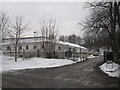
4
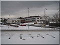
Millburn Academy
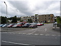
Millburn Academy is a six year secondary school serving the area of Inverness east of the River Ness and the rural areas to the south of the city. The school first opened in 1961 as Millburn Junior Secondary School. In 1976 the school name was changed to Millburn Academy (as opposed to Millburn High School) after School Council pressure on the Education Committee. In January 2007 construction work began on the building of the new Millburn Academy, which opened on November 3rd 2008. The new Millburn Academy was built on the old school’s playing fields. The ground which the old school previously occupied will become the new playing fields. The £26 million state of the art building has a range of classrooms with specialist facilities, an integral base for children with additional support needs, a four court games hall, a gymnasium, dance studio, a library and a performance venue with bleacher seating.
(Information from school website: http://www.millburnacademy.co.uk/ )
The former building: Image
Image: © Richard Dorrell
Taken: 14 Dec 2012
0.17 miles
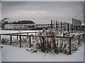
5
Council TEC Services depot, Diriebught Road
TEC stands for Transport, Environment and Community, so the depot is home to a wide range of council vehicles and equipment, mostly concerned with looking after roads, parks, pedestrian areas, refuse collection and the like.
Image: © Richard Dorrell
Taken: 14 Dec 2012
0.17 miles
6
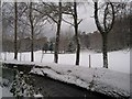
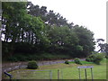
Inverness golf course
A wintry view looking over Mill Burn from Diriebught Road.
Image: © Richard Dorrell
Taken: 14 Dec 2012
0.17 miles
8

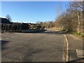
Old Perth Road approaching the Millburn Roundabout
Image: © Darrin Antrobus
Taken: 24 Sep 2013
0.20 miles
9
Millburn Academy
Millburn Academy is a six year secondary school serving the area of Inverness east of the River Ness and the rural areas to the south of the city. The school first opened in 1961 as Millburn Junior Secondary School. In 1976 the school name was changed to Millburn Academy (as opposed to Millburn High School) after School Council pressure on the Education Committee. In January 2007 construction work began on the building of the new Millburn Academy, which opened on November 3rd 2008. The new Millburn Academy was built on the old school’s playing fields. The ground which the old school previously occupied will become the new playing fields. The £26 million state of the art building has a range of classrooms with specialist facilities, an integral base for children with additional support needs, a four court games hall, a gymnasium, dance studio, a library and a performance venue with bleacher seating.
(Information from school website: http://www.millburnacademy.co.uk/ )
The former building: Image
Image: © Richard Dorrell
Taken: 14 Dec 2012
0.21 miles
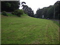
10
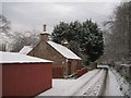
Rural village? No, city centre!
This is Diriebught Road, less than half a mile from Inverness city centre. The road is a cul-de-sac, serving just a few properties, and runs alongside Inverness Golf Course.
Same road, opposite direction: Image
Image: © Richard Dorrell
Taken: 14 Dec 2012
0.21 miles