IMAGES TAKEN NEAR TO
Ashton Crescent, INVERNESS, IV2 3UZ
Introduction
This page details the photographs taken nearby to Ashton Crescent, IV2 3UZ by members of the Geograph project.
The Geograph project started in 2005 with the aim of publishing, organising and preserving representative images for every square kilometre of Great Britain, Ireland and the Isle of Man.

There are currently over 7.5m images from over14,400 individuals and you can help contribute to the project by visiting https://www.geograph.org.uk
Image Map
Images are licensed for reuse under creativecommons.org/licenses/by-sa/2.0
Notes
- Clicking on the map will re-center to the selected point.
- The higher the marker number, the further away the image location is from the centre of the postcode.
Image Listing (50 Images Found)
Images are licensed for reuse under creativecommons.org/licenses/by-sa/2.0
Image
Details
Distance
1

Raigmore Community Centre
A well maintained community centre surrounded by a leafy park in Raigmore estate.
Image: © Richard Dorrell
Taken: 30 Jun 2009
0.10 miles
2
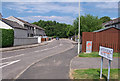
Ashton Road, Inverness
One of two cul-de-sacs in Ashton Road.
Image: © Richard Dorrell
Taken: 30 Jun 2009
0.11 miles
3
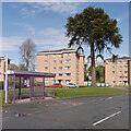
Chattan Avenue, Raigmore
Looking towards Mackintosh Road, with a bus stop, a monkey puzzle tree, and several blocks of flats.
This area was the grounds of Raigmore House, until it was demolished in 1965. Perhaps the tree was part of the original gardens.
Image: © Craig Wallace
Taken: 9 Apr 2021
0.11 miles
4

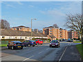
Footbridge in the park
The park incorporates a children's play area, and surrounds the Raigmore Community Centre.
The housing is in Ashton Road.
Image: © Richard Dorrell
Taken: 30 Jun 2009
0.12 miles
6
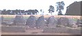
Stoneyfield Cairn
The remnants of a Clava-type cairn. I have been informed that, after this photograph was taken, the cairn was moved from its original position at NH68784549 to NH68764512 during the construction of the new A9. See http://her.highland.gov.uk/SingleResult.aspx?uid=MHG3723
Image: © Anne Burgess
Taken: Unknown
0.13 miles
7
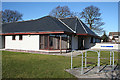
Phoenix Centre
The Centre unites under one roof the Departments of Child and Family Psychiatry, Clinical Child Psychology and Clinical Child Psychology Learning Disabilities to form the Integrated Child and Adolescent Mental Health Services. It was formerly known as the Shenavall Centre, but on completion of the new premises a competition was held among the patients to select a new name.
Image: © Anne Burgess
Taken: 28 Feb 2011
0.13 miles
8
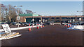
Vaccination Centre Parking, Raigmore Hospital, Inverness
The car park was virtually empty and while passing time in the hospital grounds I found no-one chose to park in this area.
Image: © Julian Paren
Taken: 10 Feb 2021
0.13 miles
9

Path from Churchill Road
The path provides a popular shortcut to the end of King Duncan's Road and the Old Perth Road.
Image: © Richard Dorrell
Taken: 30 Jun 2009
0.14 miles
10
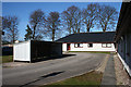
Morven House
Like its neighbours the Birnie Centre and Phoenix Centre, Morven House, which is a wing behind those buildings, houses staff concerned with child mental health, learning difficulties and support for families.
Image: © Anne Burgess
Taken: 28 Feb 2011
0.14 miles