IMAGES TAKEN NEAR TO
Dundonnell, GARVE, IV23 2QN
Introduction
This page details the photographs taken nearby to IV23 2QN by members of the Geograph project.
The Geograph project started in 2005 with the aim of publishing, organising and preserving representative images for every square kilometre of Great Britain, Ireland and the Isle of Man.

There are currently over 7.5m images from over14,400 individuals and you can help contribute to the project by visiting https://www.geograph.org.uk
Image Map
Images are licensed for reuse under creativecommons.org/licenses/by-sa/2.0
Notes
- Clicking on the map will re-center to the selected point.
- The higher the marker number, the further away the image location is from the centre of the postcode.
Image Listing (24 Images Found)
Images are licensed for reuse under creativecommons.org/licenses/by-sa/2.0
Image
Details
Distance
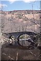
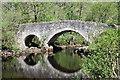
1
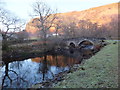
Bridge on the road to Badrallach near Dundonnell House
Chilly Sunday afternoon on the road to Badrallach
Image: © murdoch sutherland
Taken: 15 Jan 2012
0.08 miles
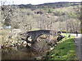
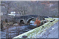
4
Bridge over Dundonnell River, Badralloch road.
Cold November day before sleat & snow showers obscured all.
Image: © djmacpherson
Taken: 9 Nov 2008
0.10 miles
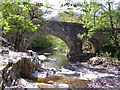
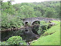
5
Bridge, Dundonnell
Old bridge near Dundonnell House.
Image: © Richard Webb
Taken: 3 May 1989
0.11 miles

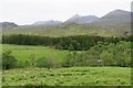
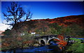
10
Bridge over the Dundonnell River
On the road to Badrallach,near Dundonnell House.
Image: © jeff collins
Taken: 30 May 2013
0.11 miles