IMAGES TAKEN NEAR TO
Naast, Poolewe, ACHNASHEEN, IV22 2LL
Introduction
This page details the photographs taken nearby to IV22 2LL by members of the Geograph project.
The Geograph project started in 2005 with the aim of publishing, organising and preserving representative images for every square kilometre of Great Britain, Ireland and the Isle of Man.

There are currently over 7.5m images from over14,400 individuals and you can help contribute to the project by visiting https://www.geograph.org.uk
Image Map
Images are licensed for reuse under creativecommons.org/licenses/by-sa/2.0
Notes
- Clicking on the map will re-center to the selected point.
- The higher the marker number, the further away the image location is from the centre of the postcode.
Image Listing (16 Images Found)
Images are licensed for reuse under creativecommons.org/licenses/by-sa/2.0
Image
Details
Distance
4
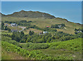
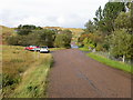
Houses at Naast
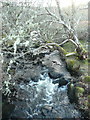
From the bridge over the Allt Donn.
Image: © Russel Wills
Taken: 10 Feb 2011
0.08 miles
5
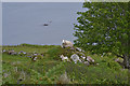
Eyeing the intruder
A ewe eyes the photographer with suspicion while her lamb munches happily on.
Image: © Nigel Brown
Taken: 18 Jun 2015
0.09 miles
7
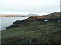
The jetty at Naast
With the mountains of Wester Ross in the distance.
Image: © Russel Wills
Taken: 10 Feb 2011
0.14 miles
8
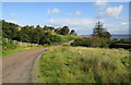
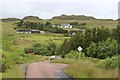
Road (B8057) entering Naast
Looking north-westward.
Image: © Peter Wood
Taken: 28 Sep 2018
0.15 miles
10
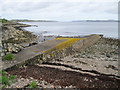
Naast Jetty
This jetty was built in WW2 for resupplying Russian Convoy ships. It appears to be constructed of sandbags, or bags of cement.
Image: © Bob Jones
Taken: 27 May 2011
0.15 miles