IMAGES TAKEN NEAR TO
GAIRLOCH, IV21 2BD
Introduction
This page details the photographs taken nearby to IV21 2BD by members of the Geograph project.
The Geograph project started in 2005 with the aim of publishing, organising and preserving representative images for every square kilometre of Great Britain, Ireland and the Isle of Man.

There are currently over 7.5m images from over14,400 individuals and you can help contribute to the project by visiting https://www.geograph.org.uk
Image Map (Loading...)


Getting Data...Please wait
Leaflet Map data © OpenStreetMap
Images are licensed for reuse under creativecommons.org/licenses/by-sa/2.0
Notes
- Clicking on the map will re-center to the selected point.
- The higher the marker number, the further away the image location is from the centre of the postcode.
Image Listing (110 Images Found)
Images are licensed for reuse under creativecommons.org/licenses/by-sa/2.0
Image
Details
Distance

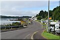
5

Gairloch harbour car park
There is space for cars despite the number of boats also 'parked' here.
Image: © Lis Burke
Taken: 18 Mar 2007
0.09 miles
8
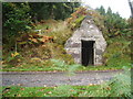
Lock-up or Ice House?
On the road up to Flowerdale House
Image: © Peter Barr
Taken: 29 Sep 2009
0.10 miles