IMAGES TAKEN NEAR TO
GAIRLOCH, IV21 2AJ
Introduction
This page details the photographs taken nearby to IV21 2AJ by members of the Geograph project.
The Geograph project started in 2005 with the aim of publishing, organising and preserving representative images for every square kilometre of Great Britain, Ireland and the Isle of Man.

There are currently over 7.5m images from over14,400 individuals and you can help contribute to the project by visiting https://www.geograph.org.uk
Image Map
Images are licensed for reuse under creativecommons.org/licenses/by-sa/2.0
Notes
- Clicking on the map will re-center to the selected point.
- The higher the marker number, the further away the image location is from the centre of the postcode.
Image Listing (34 Images Found)
Images are licensed for reuse under creativecommons.org/licenses/by-sa/2.0
Image
Details
Distance
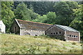
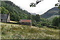
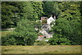
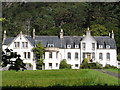
6

Flowerdale House
Flowerdale House is a large property in the valley running down to Charlestown on the shore of Loch Gairloch; it was built in 1738 for Sir Alexander Mackenzie and his wife, Janet.
Image: © Trevor Littlewood
Taken: 1 Jun 2006
0.06 miles
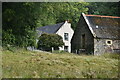
7
Flowerdale House
Built in 1738 for the Mackenzies of Gairloch. In Dixon's Gairloch published in 1886 shows the house only had the righthand end of the present one.
Image: © Roger McLachlan
Taken: 25 Aug 2005
0.09 miles