IMAGES TAKEN NEAR TO
Balnabruach, Portmahomack, TAIN, IV20 1YN
Introduction
This page details the photographs taken nearby to IV20 1YN by members of the Geograph project.
The Geograph project started in 2005 with the aim of publishing, organising and preserving representative images for every square kilometre of Great Britain, Ireland and the Isle of Man.

There are currently over 7.5m images from over14,400 individuals and you can help contribute to the project by visiting https://www.geograph.org.uk
Image Map (Loading...)


Getting Data...Please wait
Leaflet Map data © OpenStreetMap
Images are licensed for reuse under creativecommons.org/licenses/by-sa/2.0
Notes
- Clicking on the map will re-center to the selected point.
- The higher the marker number, the further away the image location is from the centre of the postcode.
Image Listing (72 Images Found)
Images are licensed for reuse under creativecommons.org/licenses/by-sa/2.0
Image
Details
Distance
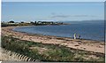
1
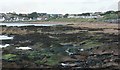
Rocks at west end of Portmahomack Bay
Portmahomack Caravan Site is on the right.
Image: © Richard Sutcliffe
Taken: 16 Sep 2017
0.02 miles
2
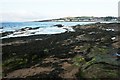
Rocks at west end of Portmahomack Bay
Image: © Richard Sutcliffe
Taken: 16 Sep 2017
0.02 miles
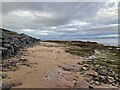
6
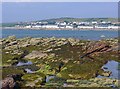
Outcropping rock below Balnabruach
The character of the beach at Portmahomack changes as you walk west as you lose the sand and gain an area of rock pools and wildlife.
Image: © Julian Paren
Taken: 24 Jul 2013
0.08 miles
8
Balnabruach, Tarbat Ness across the bay
Image: © sylvia duckworth
Taken: 23 Jan 2009
0.10 miles
9
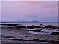
Cold sunrise, looking West from Portmahomack
Image: © sylvia duckworth
Taken: 21 Jan 2009
0.11 miles
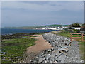
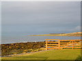
10
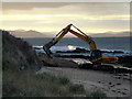
Sea-defence repairs at Balnabruach
Image: © sylvia duckworth
Taken: 9 Nov 2010
0.13 miles