IMAGES TAKEN NEAR TO
Portmahomack, TAIN, IV20 1RE
Introduction
This page details the photographs taken nearby to IV20 1RE by members of the Geograph project.
The Geograph project started in 2005 with the aim of publishing, organising and preserving representative images for every square kilometre of Great Britain, Ireland and the Isle of Man.

There are currently over 7.5m images from over14,400 individuals and you can help contribute to the project by visiting https://www.geograph.org.uk
Image Map (Loading...)


Getting Data...Please wait
Leaflet Map data © OpenStreetMap
Images are licensed for reuse under creativecommons.org/licenses/by-sa/2.0
Notes
- Clicking on the map will re-center to the selected point.
- The higher the marker number, the further away the image location is from the centre of the postcode.
Image Listing (11 Images Found)
Images are licensed for reuse under creativecommons.org/licenses/by-sa/2.0
Image
Details
Distance
2
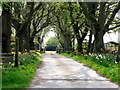
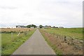
Spring flowers at Seafield.
Daffodils and tulips line this inviting avenue.
Image: © sylvia duckworth
Taken: 26 Apr 2009
0.07 miles
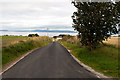
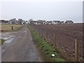
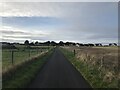
6
Winter crops near Seafield
The distant roofs are the Knock Shortie area of Portmahomack.
Image: © sylvia duckworth
Taken: 1 Jan 2012
0.15 miles
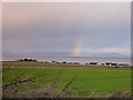
7
Passing storm, Seafield, Tarbat peninsula
Image: © sylvia duckworth
Taken: 21 Oct 2008
0.16 miles
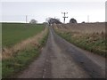
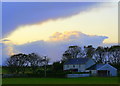
9
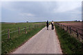
Walking the road between Portmahomack towards Rockfield
Image: © Colin Park
Taken: 16 May 1985
0.20 miles