IMAGES TAKEN NEAR TO
TAIN, IV19 1NH
Introduction
This page details the photographs taken nearby to IV19 1NH by members of the Geograph project.
The Geograph project started in 2005 with the aim of publishing, organising and preserving representative images for every square kilometre of Great Britain, Ireland and the Isle of Man.

There are currently over 7.5m images from over14,400 individuals and you can help contribute to the project by visiting https://www.geograph.org.uk
Image Map
Images are licensed for reuse under creativecommons.org/licenses/by-sa/2.0
Notes
- Clicking on the map will re-center to the selected point.
- The higher the marker number, the further away the image location is from the centre of the postcode.
Image Listing (8 Images Found)
Images are licensed for reuse under creativecommons.org/licenses/by-sa/2.0
Image
Details
Distance
2
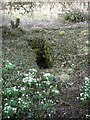
Old well, Glenaldie House
A round masonry well, about a metre across, with steps leading down, very close to the side of the burn.
Image: © sylvia duckworth
Taken: 13 Mar 2010
0.19 miles
3
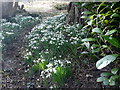
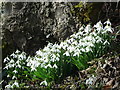
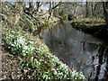
A carpet of snowdrops at Glenaldie House
Image: © sylvia duckworth
Taken: 13 Mar 2010
0.19 miles
6
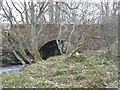
Bridge over Aldie Water
By High Mills
Image: © sylvia duckworth
Taken: 13 Mar 2010
0.23 miles