IMAGES TAKEN NEAR TO
INVERGORDON, IV18 0NF
Introduction
This page details the photographs taken nearby to IV18 0NF by members of the Geograph project.
The Geograph project started in 2005 with the aim of publishing, organising and preserving representative images for every square kilometre of Great Britain, Ireland and the Isle of Man.

There are currently over 7.5m images from over14,400 individuals and you can help contribute to the project by visiting https://www.geograph.org.uk
Image Map (Loading...)


Getting Data...Please wait
Leaflet Map data © OpenStreetMap
Images are licensed for reuse under creativecommons.org/licenses/by-sa/2.0
Notes
- Clicking on the map will re-center to the selected point.
- The higher the marker number, the further away the image location is from the centre of the postcode.
Image Listing (4 Images Found)
Images are licensed for reuse under creativecommons.org/licenses/by-sa/2.0
Image
Details
Distance
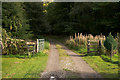
2
Giant Hogweed Erdadication
There were signs posted by the track at Tarbat Mains warning of an area of Giant Hogweed under erdaication
Image: © valenta
Taken: 23 Jul 2020
0.23 miles
3
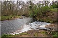
Balnagown River
A path runs parallel to the river from near Kildary to the north and ends here against this bank
Image: © valenta
Taken: 31 Jan 2020
0.24 miles