IMAGES TAKEN NEAR TO
INVERGORDON, IV18 0ND
Introduction
This page details the photographs taken nearby to IV18 0ND by members of the Geograph project.
The Geograph project started in 2005 with the aim of publishing, organising and preserving representative images for every square kilometre of Great Britain, Ireland and the Isle of Man.

There are currently over 7.5m images from over14,400 individuals and you can help contribute to the project by visiting https://www.geograph.org.uk
Image Map
Images are licensed for reuse under creativecommons.org/licenses/by-sa/2.0
Notes
- Clicking on the map will re-center to the selected point.
- The higher the marker number, the further away the image location is from the centre of the postcode.
Image Listing (12 Images Found)
Images are licensed for reuse under creativecommons.org/licenses/by-sa/2.0
Image
Details
Distance
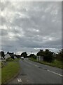
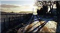
3
Speed limit warning signs approaching Barbaraville
Image: © Steven Brown
Taken: 2 May 2010
0.03 miles

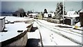
5
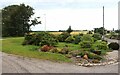
Houses at Barbaraville
Barbaraville (Scottish Gaelic: An Cladach) is a small settlement on the north shore of Nigg Bay in the Cromarty Firth
Image: © David Dixon
Taken: 19 Aug 2023
0.07 miles
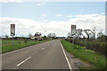
6

Towards Polnicol
Heading north east on the B817.
Image: © JThomas
Taken: 3 May 2014
0.14 miles
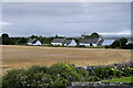
7
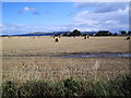
A View from Barbaraville
Taken just past Barbaraville Village
Image: © Donald H Bain
Taken: 16 Sep 2005
0.18 miles
8
View Of Sutors From Barbaraville
Looking over to Cromarty and Nigg from Barbaraville
Image: © William Grierson
Taken: Unknown
0.21 miles
10
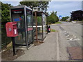
Post box, phone box, bus stop, rubbish bin, at Barbaraville
Image: © Rob Purvis
Taken: 26 Jun 2018
0.22 miles