IMAGES TAKEN NEAR TO
Shore Road, INVERGORDON, IV18 0EX
Introduction
This page details the photographs taken nearby to Shore Road, IV18 0EX by members of the Geograph project.
The Geograph project started in 2005 with the aim of publishing, organising and preserving representative images for every square kilometre of Great Britain, Ireland and the Isle of Man.

There are currently over 7.5m images from over14,400 individuals and you can help contribute to the project by visiting https://www.geograph.org.uk
Image Map
Images are licensed for reuse under creativecommons.org/licenses/by-sa/2.0
Notes
- Clicking on the map will re-center to the selected point.
- The higher the marker number, the further away the image location is from the centre of the postcode.
Image Listing (114 Images Found)
Images are licensed for reuse under creativecommons.org/licenses/by-sa/2.0
Image
Details
Distance
1
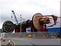
Ocean Power Technology PB150 wave-power generator
Generating electricity from wave-energy, the foot of this machine (on the left) is anchored to the seabed; the yellow disc floats above, rising and falling with wave action. This motion is used to drive a generator in the middle of the stem, sending power onshore via a subsea cable.
Image: © sylvia duckworth
Taken: 28 Oct 2011
0.03 miles
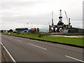
2
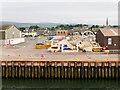
Wharf at Invergordon Port
Invergordon is a small town and port on the northern shore of the Cromarty Firth. It was a naval base in the early 20th century and the town is well known for the Invergordon Mutiny of 1931 https://en.wikipedia.org/wiki/Invergordon_Mutiny . More recently Invergordon has become known for the repair of oil rigs which line up in the Cromarty Firth and the port is visited by many large cruise liners each year, as the deep water port allows disembarkation for coach tours in the northern Highlands.
Image: © David Dixon
Taken: 9 Jul 2016
0.03 miles
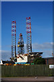
3
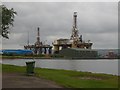
Two Rigs in for Maintenance
Busy Rig maintenance yard
Image: © John Forret
Taken: 6 Aug 2008
0.06 miles
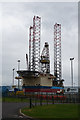
4
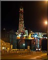
Transocean Leader Invergordon
The Tansocean Leader drilling rig undergoing maintenance at Invergordon
Image: © valenta
Taken: 21 Dec 2019
0.07 miles

7
Invergordon, Queen's Dock from Shore Road
Invergordon is a small town and port on the northern shore of the Cromarty Firth. It was a naval base in the early 20th century and the town is well known for the Invergordon Mutiny of 1931 https://en.wikipedia.org/wiki/Invergordon_Mutiny . More recently Invergordon has become known for the repair of oil rigs which line up in the Cromarty Firth and the port is visited by many large cruise liners each year, as the deep water port allows disembarkation for coach tours in the northern Highlands.
In this photograph, the drilling platform Parragon MSS1 http://www.marinetraffic.com/en/ais/details/ships/shipid:3412947/mmsi:636011822/imo:8752790/vessel:PARAGON_MSS1 is in Invergordon's Queen's Dock.
Image: © David Dixon
Taken: 9 Jul 2016
0.08 miles
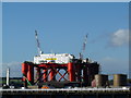
9

Oil Rigs at Invergordon on the Cromarty Firth
Image: © Andrew Tryon
Taken: 23 Nov 2013
0.08 miles
10
"Borgholm Dolphin" drilling rig at Invergordon
The rig is being refitted at Invergordon for a BP drilling progam in the North Sea.
Image: © sylvia duckworth
Taken: 5 Oct 2010
0.08 miles