IMAGES TAKEN NEAR TO
High Street, INVERGORDON, IV18 0AR
Introduction
This page details the photographs taken nearby to High Street, IV18 0AR by members of the Geograph project.
The Geograph project started in 2005 with the aim of publishing, organising and preserving representative images for every square kilometre of Great Britain, Ireland and the Isle of Man.

There are currently over 7.5m images from over14,400 individuals and you can help contribute to the project by visiting https://www.geograph.org.uk
Image Map
Images are licensed for reuse under creativecommons.org/licenses/by-sa/2.0
Notes
- Clicking on the map will re-center to the selected point.
- The higher the marker number, the further away the image location is from the centre of the postcode.
Image Listing (203 Images Found)
Images are licensed for reuse under creativecommons.org/licenses/by-sa/2.0
Image
Details
Distance
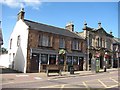
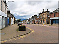
1
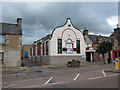
High Street looking west
Nowhere would look inviting on a day as gloomy as this. The distant background is washed out because the snow on the hills merges with the sky.
Image: © Anne Burgess
Taken: 21 Jan 2008
0.02 miles
2
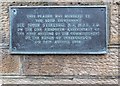
Plaque on Invergordon Burgh Chambers
A view of the building here Image]
Image: © valenta
Taken: 6 Jan 2019
0.02 miles
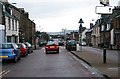
3
Invergordon Public Library, High Street, Invergordon
Image: © Ian S
Taken: 19 Jun 2018
0.03 miles
4
Invergordon Public Library
Located in the High Street. Originally built as an annex to the Higher Grade building of the original Invergordon Academy (now Park Primary School - see Image]).
Image: © Richard Dorrell
Taken: 1 Aug 2016
0.03 miles
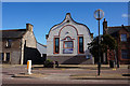
5
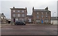
Former RBS and Burgh Chambers Building Invergordon
The building on the left is the former category B listed Royal Bank of Scotland which dates from 1856. It now houses a Vets practice, although still retaining a cash dispensing machine between the two buildings.
The building to the right is the former Burgh Chambers, category C listed, it bears a plaque on the wall dating from 1864 Image]
Image: © valenta
Taken: 6 Jan 2019
0.03 miles
6
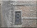
OS Flush Bracket, Invergordon
Flush bracket G1968. Recorded on Benchmark Database as 'Invergordon, High Street'.
Image: © David Bremner
Taken: 18 Sep 2022
0.03 miles
7
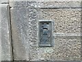
Ordnance Survey Flush Bracket G1968
This bracket con be found on the roadside wall of a building in High Street, Invergordon.
The recorded details give a height of 7.1362 metres above sea level.
For more details see : https://www.bench-marks.org.uk/bm408
Image: © Peter Wood
Taken: 9 Sep 2021
0.03 miles
9
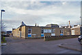
Park Primary School
This is the more modern part of the school, seen from Joss Street. See also: Image
Image: © Richard Dorrell
Taken: 15 Dec 2019
0.04 miles