IMAGES TAKEN NEAR TO
Shillinghill, ALNESS, IV17 0SZ
Introduction
This page details the photographs taken nearby to Shillinghill, IV17 0SZ by members of the Geograph project.
The Geograph project started in 2005 with the aim of publishing, organising and preserving representative images for every square kilometre of Great Britain, Ireland and the Isle of Man.

There are currently over 7.5m images from over14,400 individuals and you can help contribute to the project by visiting https://www.geograph.org.uk
Image Map
Images are licensed for reuse under creativecommons.org/licenses/by-sa/2.0
Notes
- Clicking on the map will re-center to the selected point.
- The higher the marker number, the further away the image location is from the centre of the postcode.
Image Listing (52 Images Found)
Images are licensed for reuse under creativecommons.org/licenses/by-sa/2.0
Image
Details
Distance
1
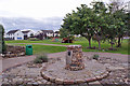
Shillinghill Park and Gardens
(From an information board in the park) 'The park and gardens were laid out and built by the town's Shillinghill Residents Association which began in 1999 on the site of a quarry seam. The project took many hours of hard labour over the period of three years - and is still ongoing - by residents as young as three years of age to many retired folk well into their seventies. Three months of work in the early stages involved lifting stones off the site and five large pits were dug to bury tons of rock and large boulders'
The plaque on the cairn reads: 'This park was created by Shillinghill Residents Association. Opened by Cllr. A Anderson 7th September 2002'
Image: © Richard Dorrell
Taken: 4 Oct 2016
0.08 miles
2
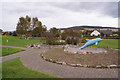
Shillinghill Park and Gardens
Public park created by the local residents association.
More information: Image
Image: © Richard Dorrell
Taken: 4 Oct 2016
0.08 miles
3
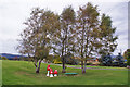
Shillinghill Park and Gardens
Public park created by the local residents association.
More information: Image
Image: © Richard Dorrell
Taken: 4 Oct 2016
0.08 miles
4
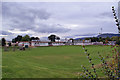
Bridgend Primary School, Alness
The school, which was first occupied in April 1962, provides accommodation for about 400 pupils and offers both nursery and primary education. In January 2016, the school roll was 284 (236 Primary 1 – 7, and 48 Nursery).
Image: © Richard Dorrell
Taken: 4 Oct 2016
0.13 miles
5
Rosskeen Church of Scotland
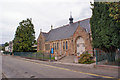
The building is dated 1910, and is located in Perrins Road, Alness.
Image: © Richard Dorrell
Taken: 4 Oct 2016
0.13 miles
6
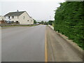
Caplich Road, Alness
Looking north-westward.
Image: © Peter Wood
Taken: 9 Sep 2021
0.14 miles
7
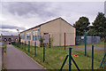
Bridgend Centre, Alness
Standing within the fenced grounds of Bridgend Primary School, the centre offers education for pupils with learning difficulties.
Image: © Richard Dorrell
Taken: 4 Oct 2016
0.15 miles
8
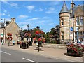
Royal Bank of Scotland, right
Summer floral displays along the High Street, Alness
Image: © gordon
Taken: 25 Aug 2004
0.20 miles
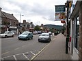
10

High Street, Alness
Looking towards the town centre from near the Perrins Centre and war memorial.
Image: © Bob Embleton
Taken: 3 Aug 2010
0.20 miles