IMAGES TAKEN NEAR TO
Darroch Drive, ALNESS, IV17 0SQ
Introduction
This page details the photographs taken nearby to Darroch Drive, IV17 0SQ by members of the Geograph project.
The Geograph project started in 2005 with the aim of publishing, organising and preserving representative images for every square kilometre of Great Britain, Ireland and the Isle of Man.

There are currently over 7.5m images from over14,400 individuals and you can help contribute to the project by visiting https://www.geograph.org.uk
Image Map
Images are licensed for reuse under creativecommons.org/licenses/by-sa/2.0
Notes
- Clicking on the map will re-center to the selected point.
- The higher the marker number, the further away the image location is from the centre of the postcode.
Image Listing (7 Images Found)
Images are licensed for reuse under creativecommons.org/licenses/by-sa/2.0
Image
Details
Distance
1
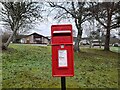
Postbox at Darroch Brae, Alness
IV17 16. Royal Mail list this box as 'Darroch Brae'.
Image: © David Bremner
Taken: 19 Dec 2021
0.08 miles
2
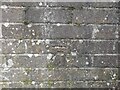
O.S Benchmark: Alness, Upper Burnside
An O.S cut benchmark on a block of garages.
Image: © David Bremner
Taken: 19 Dec 2021
0.09 miles
3
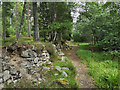
Walled track in Coulhill Wood
A straight track that has obvious antiquity
Image: © Julian Paren
Taken: 26 Jul 2019
0.18 miles
4
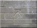
O.S Benchmark: Alness, Lower Burnside
An O.S cut benchmark on a block of garages.
Image: © David Bremner
Taken: 19 Dec 2021
0.19 miles
5
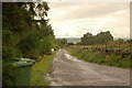
Minor road to Alness
by Coul Hill. Further downhill the road is closed and has been partially washed away by flood water.
Image: © Steven Brown
Taken: 26 Jul 2007
0.22 miles
6
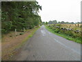
Minor road beside Coulhill Wood
Looking southward.
Image: © Peter Wood
Taken: 9 Sep 2021
0.23 miles
7
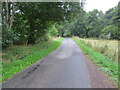
Minor road at Burnside, Alness
Looking south-eastward.
Image: © Peter Wood
Taken: 9 Sep 2021
0.24 miles