IMAGES TAKEN NEAR TO
Hill Terrace, ALNESS, IV17 0QN
Introduction
This page details the photographs taken nearby to Hill Terrace, IV17 0QN by members of the Geograph project.
The Geograph project started in 2005 with the aim of publishing, organising and preserving representative images for every square kilometre of Great Britain, Ireland and the Isle of Man.

There are currently over 7.5m images from over14,400 individuals and you can help contribute to the project by visiting https://www.geograph.org.uk
Image Map (Loading...)


Getting Data...Please wait
Leaflet Map data © OpenStreetMap
Images are licensed for reuse under creativecommons.org/licenses/by-sa/2.0
Notes
- Clicking on the map will re-center to the selected point.
- The higher the marker number, the further away the image location is from the centre of the postcode.
Image Listing (50 Images Found)
Images are licensed for reuse under creativecommons.org/licenses/by-sa/2.0
Image
Details
Distance
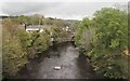
1
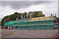
From the High Street over Alness Bridge
The bridge spans the River Averon. The road is the B817. The green mesh in the background covers a renovation project by the Highland Council which will provide six new homes for affordable rent.
See also: Image
Image: © Richard Dorrell
Taken: 4 Oct 2016
0.06 miles
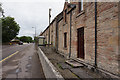
2
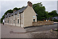
Restored homes
Located in Novar Road, immediately west of Alness Bridge, this restoration project by the Highland Council will see six new council homes available for affordable rent, ready for occupation in Spring 2017.
Image: © Richard Dorrell
Taken: 4 Oct 2016
0.06 miles
4
The High Street leaving Alness over the River Averon
Having delayed our departure, we missed the earlier heavy rainfall.
Image: © Tim Heaton
Taken: 13 May 2018
0.07 miles
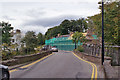
5

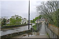
Bridges over the Averon
The old bridge is too narrow to allow pedestrians to use it with the motorised traffic so a footbridge has been built alongside.
Since the construction of the Alness by-pass for the A9 the route through the town using this bridge has been downgraded to the B817.
Image: © Bob Embleton
Taken: 3 Aug 2010
0.07 miles
6

River Averon
Also known as the Alness River.
Looking upstream from the footbridge added next to the otherwise narrow road bridge.
Image: © Bob Embleton
Taken: 3 Aug 2010
0.08 miles
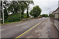
7
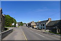
Novar Road, Alness
Westmore Bed and Breakfast on the right
Image: © Tim Heaton
Taken: 12 May 2018
0.09 miles