IMAGES TAKEN NEAR TO
Ardross Road, ALNESS, IV17 0PU
Introduction
This page details the photographs taken nearby to Ardross Road, IV17 0PU by members of the Geograph project.
The Geograph project started in 2005 with the aim of publishing, organising and preserving representative images for every square kilometre of Great Britain, Ireland and the Isle of Man.

There are currently over 7.5m images from over14,400 individuals and you can help contribute to the project by visiting https://www.geograph.org.uk
Image Map
Images are licensed for reuse under creativecommons.org/licenses/by-sa/2.0
Notes
- Clicking on the map will re-center to the selected point.
- The higher the marker number, the further away the image location is from the centre of the postcode.
Image Listing (83 Images Found)
Images are licensed for reuse under creativecommons.org/licenses/by-sa/2.0
Image
Details
Distance
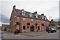
3
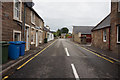
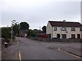
Ardross Street, Alness
Looking towards the High Street.
Image: © Richard Webb
Taken: 5 Aug 2015
0.02 miles
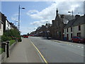
4
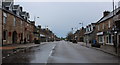
Alness on a Wet Morning
Looking down High Street
Image: © Chris Heaton
Taken: 13 May 2018
0.02 miles
6
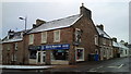
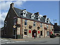
Commercial Hotel, Alness
Not much appears to have changed since 2014 - see Image
Located at 23, High Street, at the junction with Ardross Road, the hotel was built around the beginning of the 20th century.
Image: © Richard Dorrell
Taken: 4 Oct 2016
0.02 miles
8
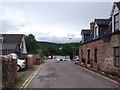
Ardross Place
Off Ardross Street, Alness.
Image: © Richard Webb
Taken: 5 Aug 2015
0.03 miles
10
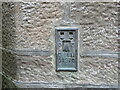
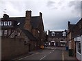
Ordnance Survey Flush Bracket G1970
This bracket can be found on the wall of the former Town Hall in High Street, Alness.
The recorded details give a height of 22.5065 metres above sea level.
For more details see : https://www.bench-marks.org.uk/bm409
Image: © Peter Wood
Taken: 9 Sep 2021
0.04 miles