IMAGES TAKEN NEAR TO
Evanton, DINGWALL, IV16 9UX
Introduction
This page details the photographs taken nearby to IV16 9UX by members of the Geograph project.
The Geograph project started in 2005 with the aim of publishing, organising and preserving representative images for every square kilometre of Great Britain, Ireland and the Isle of Man.

There are currently over 7.5m images from over14,400 individuals and you can help contribute to the project by visiting https://www.geograph.org.uk
Image Map
Images are licensed for reuse under creativecommons.org/licenses/by-sa/2.0
Notes
- Clicking on the map will re-center to the selected point.
- The higher the marker number, the further away the image location is from the centre of the postcode.
Image Listing (8 Images Found)
Images are licensed for reuse under creativecommons.org/licenses/by-sa/2.0
Image
Details
Distance
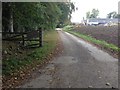

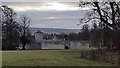
3
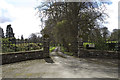
Foulis Castle
Foulis Castle has been the seat of the clan Munro for over 800 years. The existing castle was rebuilt after it was burnt by the Jacobites in 1745. The photograph shows the rear driveway, which is no longer in use.
Image: © Alasdair Macdonald
Taken: 8 Jan 2008
0.19 miles
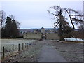
6
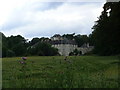
Foulis Castle
A site visitor adds, 'Foulis Castle has been a principal seat of the Clan Munro for nearly seven centuries. http://www.clanmunro.org.uk/castle.htm '
Image: © Brian MacLennan
Taken: 23 Jul 2006
0.21 miles