IMAGES TAKEN NEAR TO
DINGWALL, IV15 9TJ
Introduction
This page details the photographs taken nearby to IV15 9TJ by members of the Geograph project.
The Geograph project started in 2005 with the aim of publishing, organising and preserving representative images for every square kilometre of Great Britain, Ireland and the Isle of Man.

There are currently over 7.5m images from over14,400 individuals and you can help contribute to the project by visiting https://www.geograph.org.uk
Image Map (Loading...)


Getting Data...Please wait
Leaflet Map data © OpenStreetMap
Images are licensed for reuse under creativecommons.org/licenses/by-sa/2.0
Notes
- Clicking on the map will re-center to the selected point.
- The higher the marker number, the further away the image location is from the centre of the postcode.
Image Listing (8 Images Found)
Images are licensed for reuse under creativecommons.org/licenses/by-sa/2.0
Image
Details
Distance
1
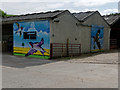
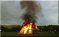
Art where least expected: farm buildings at Knockbain
Brightening up the feel of the farm.
Image: © Julian Paren
Taken: 12 Jun 2018
0.02 miles
3
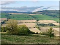
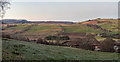
Farmland of Strath Peffer
A view across the valley to the productive south-facing slopes.
Image: © Julian Paren
Taken: 25 Sep 2017
0.14 miles
4
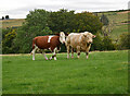
Cattle, Knockbain
A bull and a cow, at Knockbain Farm.
Image: © Craig Wallace
Taken: 14 Sep 2020
0.17 miles
5
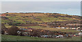
Western fringe of Dingwall
View from Knockbain over the western fringe of Dingwall
Image: © valenta
Taken: 24 Dec 2018
0.18 miles
6
View over Dingwall
View from Knockbain over the fringe of Dingwall
Image: © valenta
Taken: 24 Dec 2018
0.18 miles
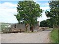
8
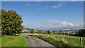
Descending to Dingwall from Knockbain
The Knockbain road gives a fine view overlooking Dingwall to the Cromarty Firth.
Image: © Julian Paren
Taken: 25 Sep 2017
0.19 miles