IMAGES TAKEN NEAR TO
Burns Crescent, DINGWALL, IV15 9QE
Introduction
This page details the photographs taken nearby to Burns Crescent, IV15 9QE by members of the Geograph project.
The Geograph project started in 2005 with the aim of publishing, organising and preserving representative images for every square kilometre of Great Britain, Ireland and the Isle of Man.

There are currently over 7.5m images from over14,400 individuals and you can help contribute to the project by visiting https://www.geograph.org.uk
Image Map (Loading...)


Getting Data...Please wait
Leaflet Map data © OpenStreetMap
Images are licensed for reuse under creativecommons.org/licenses/by-sa/2.0
Notes
- Clicking on the map will re-center to the selected point.
- The higher the marker number, the further away the image location is from the centre of the postcode.
Image Listing (35 Images Found)
Images are licensed for reuse under creativecommons.org/licenses/by-sa/2.0
Image
Details
Distance
1
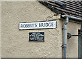
Robert's Bridge - plaque on a wall
Close-up of a plaque attached to the wall of a residential property in Burns Crescent, Dingwall.
The plaque reads: Robert's Bridge. The stone bridge which here crossed the River Peffery was named The Bridge of Robert Munro early in the 16th century. Clan Munro (Association).
Wider view: Image
Image: © Richard Dorrell
Taken: 13 Jun 2019
0.06 miles
2
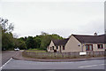
Burns Crescent and Back Road, Dingwall
A plaque on the near corner of the residential property on the right provides a little local history information.
See : Image
The white vehicle on the left is just crossing the present Robert's Bridge.
Image: © Richard Dorrell
Taken: 13 Jun 2019
0.07 miles
3
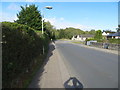
Bridgend Avenue in Dingwall
Looking north-eastward.
Image: © Peter Wood
Taken: 27 Sep 2018
0.07 miles
4
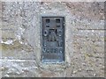
Ordnance Survey Flush Bracket G4466
This can be found on the wall of a house in Strathpeffer Road, Dingwall. The benchmark height is recorded as being 6.885 metres above sea level.
For more detail see : https://www.bench-marks.org.uk/bm17171
Image: © Peter Wood
Taken: 27 Sep 2018
0.08 miles
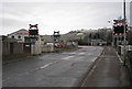
6
Enforcement Camera at Level Crossing
This state-of-the-art looking bit of equipment, manufactured by a company called Vysionics, is there to deter, and if that doesn't work, detect and prosecute motorists who cross over the railway when the flashing lights instruct them not to. There is a picture on the site from 2013 showing that not that long ago there weren't even any barriers operating at the most Westerly of Dingwall's three level crossings.
When a train is approaching an amber light at the bottom of the black board lights up. This is shortly followed by two red lights at the top of the board flashing alternately - this type of warning light is known as a wig-wag light, and is used as it is more obvious than the standard steady red light used on traffic lights. Half barriers are starting to be used as the standard at level crossings. Despite the obvious drawback that vehicles can zig-zag through them, the thinking must be that it is worth it in case the unthinkable happens - somebody stalling or finding themselves stuck in the middle in a traffic jam when the barriers descend.
Image: © Ian Dodds
Taken: 28 Jun 2021
0.10 miles
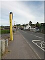
8
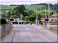
Level crossing, Dingwall
This is the most westerly of three level crossings within the small town of Dingwall. Here, the Inverness to Kyle of Lochalsh line crosses the A834, Bridgend Avenue. The crossing has no gates or barriers.
The business just beyond the crossing on the left is a farm and garden machinery supplier.
Image: © Richard Dorrell
Taken: 17 Jan 2013
0.11 miles
9
Dingwall No 2 Level Crossing, Mill Street
Image: © David Dixon
Taken: 22 Jun 2022
0.11 miles
10
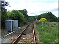
Railway heading west
Towards Kyle of Lochalsh.
Image: © JThomas
Taken: 21 Jul 2014
0.13 miles