IMAGES TAKEN NEAR TO
Macbeth Court, DINGWALL, IV15 9AF
Introduction
This page details the photographs taken nearby to Macbeth Court, IV15 9AF by members of the Geograph project.
The Geograph project started in 2005 with the aim of publishing, organising and preserving representative images for every square kilometre of Great Britain, Ireland and the Isle of Man.

There are currently over 7.5m images from over14,400 individuals and you can help contribute to the project by visiting https://www.geograph.org.uk
Image Map
Images are licensed for reuse under creativecommons.org/licenses/by-sa/2.0
Notes
- Clicking on the map will re-center to the selected point.
- The higher the marker number, the further away the image location is from the centre of the postcode.
Image Listing (16 Images Found)
Images are licensed for reuse under creativecommons.org/licenses/by-sa/2.0
Image
Details
Distance
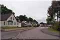
1
Scott Crescent, Dingwall
Residential development to the north of the Old Evanton Road, north east of the town centre.
Image: © Richard Dorrell
Taken: 13 Jun 2019
0.07 miles
2

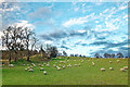
Sheep in fields above Dingwall
A number of farmers overwinter sheep from the west coast of Scotland so to benefit from better conditions at a harsh time of the year on the West Coast.
Image: © Julian Paren
Taken: 19 Nov 2022
0.15 miles
3
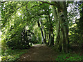
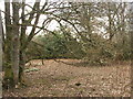
Woodland path, Eastend Wood, Dingwall
Part of a short circuit from a housing estate.
Image: © Julian Paren
Taken: 28 Jun 2019
0.16 miles
4
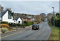
Old Evanton Road
Looking towards the edge of Dingwall.
Image: © Mary and Angus Hogg
Taken: 28 Mar 2013
0.17 miles
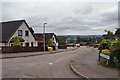
5
Bruce Court, Dingwall
Cul-de-sac of large detached properties in at the edge of a residential development off the Old Evanton Road.
Image: © Richard Dorrell
Taken: 13 Jun 2019
0.17 miles
6
Farmland above Dingwall
Still grass for the sheep to eat. In less favoured sites and less managed fields the sheep would be eating hay.
Image: © Julian Paren
Taken: 19 Nov 2022
0.19 miles
7
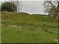
Site of Former Quarry near Tulloch
The first 1870s OS map of here shows the mound but gives no indication of what it is; the second map from about 30 years later denotes it as a former quarry. As usual with quarries, online investigations reveal next to nothing - mining and railways seem to be the internet's biggest historical concerns by far!
I recently discovered an incredibly useful old book freely available to view online. It is titled 'A Topographical History of Scotland...' and dates from 1846. Reprints are available but the original will now set you back £200 to £300. All of Scotland's larger settlements of the time are covered, often in great detail. All it mentions about quarrying in Dingwall is that there were three working quarries at the time, and all of them sandstone. This adds up as every old building in the town is built from the stuff - indeed it could be argued that Dingwall actually has its own architectural style.
Image: © Ian Dodds
Taken: 30 Jun 2021
0.21 miles
8
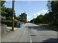
Old Evanton Road
National Cycle Route 1 heading north east.
Image: © JThomas
Taken: 21 Jul 2014
0.21 miles
10
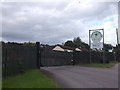
Munro Sawmills
Old Evanton Road, Dingwall.
Image: © Richard Webb
Taken: 4 Aug 2015
0.22 miles