IMAGES TAKEN NEAR TO
STRATHPEFFER, IV14 9DQ
Introduction
This page details the photographs taken nearby to IV14 9DQ by members of the Geograph project.
The Geograph project started in 2005 with the aim of publishing, organising and preserving representative images for every square kilometre of Great Britain, Ireland and the Isle of Man.

There are currently over 7.5m images from over14,400 individuals and you can help contribute to the project by visiting https://www.geograph.org.uk
Image Map
Images are licensed for reuse under creativecommons.org/licenses/by-sa/2.0
Notes
- Clicking on the map will re-center to the selected point.
- The higher the marker number, the further away the image location is from the centre of the postcode.
Image Listing (180 Images Found)
Images are licensed for reuse under creativecommons.org/licenses/by-sa/2.0
Image
Details
Distance
2
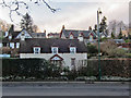
Raven's Cottage
The cottage was present on the OS 1st edition map (1876), and is one of the oldest existing buildings in Strathpeffer village. A photograph of the cottage taken in 1949, shows it with a thatched roof, though the thatch has now been replaced with tiles.
Image: © Richard Dorrell
Taken: 23 Feb 2020
0.03 miles
3
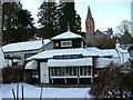
The Shieling, Strathpeffer
A former knitwear and souvenir shop, now apparently for sale.
Image: © Dave Fergusson
Taken: 24 Dec 2010
0.03 miles
4
Timaru, Strathpeffer
One of many fine Victorian houses in the village.
This house was built after 1873 by Donald MacLennan (b. 1838) who lived for some time in Timaru in New Zealand. Donald was known locally as ‘Old Timaru’ and died in Strathpeffer in 1919.
Image: © Richard Dorrell
Taken: 7 Sep 2019
0.03 miles
5
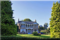
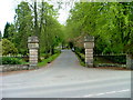
Entrance to Eaglestone House
The house is present on the OS 1st edition map (1876). It is Category B listed. During the 1920s-1930s, a Dr. Bearn had his surgery in the house.
In 2000, the house was bought by singer-songwriter Gerry Rafferty. He owned the house for about 2 years, though he never actually moved in.
Image: © Richard Dorrell
Taken: 23 Feb 2020
0.04 miles
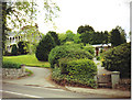
6
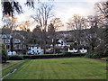
Strathpeffer village from Ben Wyvis Hotel grounds
Looking over a lawned area within the grounds of the Ben Wyvis Hotel. Just beyond the hedge is the A834 main road. On the left, the large grey building is Cromartie House. Now flats, this building used to house a bakery shop and popular tea rooms. The white building behind it is The Old Bakery, built about 1890, and actually built as store rooms for the bakery which served the shop and tea rooms. The bakery itself is long-since demolished. Right of centre is a modern house. The white cottage on the right is Raven's Cottage, built before 1875, and one of the oldest existing houses in the village.
Image: © Richard Dorrell
Taken: 23 Feb 2020
0.04 miles
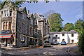
7
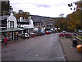
Strathpeffer Centre
The shopping centre of Strathpeffer
Image: © Keith Laverack
Taken: 18 Oct 2004
0.04 miles
8
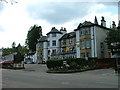
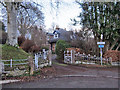
Entrance to Ben Wyvis Hotel
Strathpeffer.
Image: © Dave Fergusson
Taken: 18 May 2010
0.04 miles
10
Cromartie Buildings, Strathpeffer
(See also Image]). The substantial building on the left is Cromartie House. It is now divided into private flats, but was built in 1885 as a lodging house with shops below. The white building at the rear is named The Old Bakery, though it was more probably store rooms for the bakery and garage for the delivery van, as the bake house itself has been demolished, and no trace of it remains. The Old Bakery is now a private dwelling.
Image: © Richard Dorrell
Taken: 23 Jul 2018
0.05 miles