IMAGES TAKEN NEAR TO
Park Road, STRATHPEFFER, IV14 9BY
Introduction
This page details the photographs taken nearby to Park Road, IV14 9BY by members of the Geograph project.
The Geograph project started in 2005 with the aim of publishing, organising and preserving representative images for every square kilometre of Great Britain, Ireland and the Isle of Man.

There are currently over 7.5m images from over14,400 individuals and you can help contribute to the project by visiting https://www.geograph.org.uk
Image Map
Images are licensed for reuse under creativecommons.org/licenses/by-sa/2.0
Notes
- Clicking on the map will re-center to the selected point.
- The higher the marker number, the further away the image location is from the centre of the postcode.
Image Listing (38 Images Found)
Images are licensed for reuse under creativecommons.org/licenses/by-sa/2.0
Image
Details
Distance
1
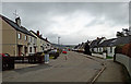
Park Terrace, Strathpeffer
Presumably named because the road follows the contour of the hillside, as there are no terraced houses here.
Image: © Richard Dorrell
Taken: 19 Mar 2019
0.04 miles
2
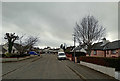
Park Terrace, Strathpeffer
Mixed housing in a cul-de-sac road south of the village centre.
Image: © Richard Dorrell
Taken: 19 Mar 2019
0.11 miles
3
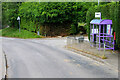
Park Avenue Bus Stop at Strathpeffer
Bus stop on the A834 into Strathpeffer.
Image: © David Dixon
Taken: 23 Jun 2022
0.11 miles
4
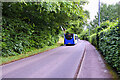
A834 near to Strathpeffer
The A834 leaving Strathpeffer to the west.
Image: © David Dixon
Taken: 21 Jun 2022
0.12 miles
5
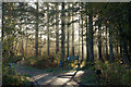
Track to Blackmuir Wood, Strathpeffer
Forest car park and trails just SW of Strathpeffer. Unfortunately, some of the walks were closed off due to forestry work, but there are several alternatives within walking distance.
Image: © Jim Barton
Taken: 7 Nov 2009
0.13 miles
6
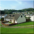
Housing Estate in Strathpeffer
Viewed from the A834.
Image: © Clint Mann
Taken: 15 Sep 2016
0.14 miles
7
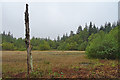
Lochan in the woods
In the woods above Strathpeffer
Image: © John MacKenzie
Taken: 25 Dec 2008
0.14 miles
8
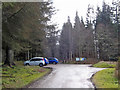
Blackmuir Wood car park
A Forestry Commission wood. Within the woodland are waymarked trails for short strolls as well as serious walks.
Image: © Richard Dorrell
Taken: 15 Mar 2020
0.15 miles
9
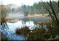
Jubilee Pond
I thought this pond might originally have been a kettle hole. However it does not appear on the first edition of the Ordnance Survey map, though it is on the second edition and the 25-inch map, so I investigated. It turns out to have been created as a public curling and skating pond to commemorate Queen Victoria's Golden Jubilee in 1887.
Image: © Anne Burgess
Taken: 3 Oct 2018
0.15 miles
10
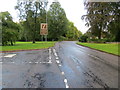
Road (A834) entering Strathpeffer
Looking north-westward from Kinellan Drive.
Image: © Peter Wood
Taken: 27 Sep 2018
0.15 miles