IMAGES TAKEN NEAR TO
Moy, Tomatin, INVERNESS, IV13 7YG
Introduction
This page details the photographs taken nearby to IV13 7YG by members of the Geograph project.
The Geograph project started in 2005 with the aim of publishing, organising and preserving representative images for every square kilometre of Great Britain, Ireland and the Isle of Man.

There are currently over 7.5m images from over14,400 individuals and you can help contribute to the project by visiting https://www.geograph.org.uk
Image Map
Images are licensed for reuse under creativecommons.org/licenses/by-sa/2.0
Notes
- Clicking on the map will re-center to the selected point.
- The higher the marker number, the further away the image location is from the centre of the postcode.
Image Listing (6 Images Found)
Images are licensed for reuse under creativecommons.org/licenses/by-sa/2.0
Image
Details
Distance
4
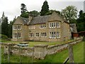
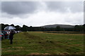
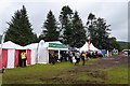
Moy Hall - or a part of it
Taken during the annual Moy Country Fair, a three-day display of events, activities and "country pursuits" attended by large crowds
Image: © nairnbairn
Taken: 3 Aug 2007
0.21 miles