IMAGES TAKEN NEAR TO
NAIRN, IV12 5NY
Introduction
This page details the photographs taken nearby to IV12 5NY by members of the Geograph project.
The Geograph project started in 2005 with the aim of publishing, organising and preserving representative images for every square kilometre of Great Britain, Ireland and the Isle of Man.

There are currently over 7.5m images from over14,400 individuals and you can help contribute to the project by visiting https://www.geograph.org.uk
Image Map (Loading...)


Getting Data...Please wait
Leaflet Map data © OpenStreetMap
Images are licensed for reuse under creativecommons.org/licenses/by-sa/2.0
Notes
- Clicking on the map will re-center to the selected point.
- The higher the marker number, the further away the image location is from the centre of the postcode.
Image Listing (13 Images Found)
Images are licensed for reuse under creativecommons.org/licenses/by-sa/2.0
Image
Details
Distance
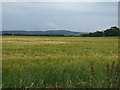
1
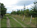
Track at Easter Lochend
The start of a track giving access to the fields of Easter Lochend Farm.
Image: © John Allan
Taken: 7 Aug 2006
0.08 miles
2
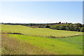
Looking East to Meikle Kildrummie from Easter Lochend
Image: © Sarah McGuire
Taken: 6 Jan 2009
0.08 miles
3
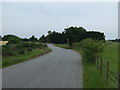
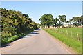
B9091 heading west, Easter Lochend
Towards Inverness.
Image: © JThomas
Taken: 19 Jul 2014
0.08 miles
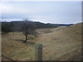
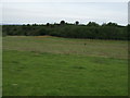
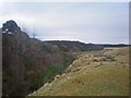
5
Fields and eskers near Easter Lochend Farm
Image: © Steven Brown
Taken: 15 Aug 2010
0.11 miles
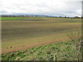
8
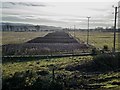
Field system at Easter Lochend
Newly ploughed field, the low sun emphasizing the undulating ground
Image: © valenta
Taken: 16 Feb 2018
0.18 miles
10
Burn Crossing Easter Lochend
The north banking of burn is densely covered in whins which are impenetrable, hiding completely the Fort marked on maps.
Image: © Sarah McGuire
Taken: 6 Jan 2009
0.20 miles