IMAGES TAKEN NEAR TO
Ordview Road, NAIRN, IV12 5NL
Introduction
This page details the photographs taken nearby to Ordview Road, IV12 5NL by members of the Geograph project.
The Geograph project started in 2005 with the aim of publishing, organising and preserving representative images for every square kilometre of Great Britain, Ireland and the Isle of Man.

There are currently over 7.5m images from over14,400 individuals and you can help contribute to the project by visiting https://www.geograph.org.uk
Image Map
Images are licensed for reuse under creativecommons.org/licenses/by-sa/2.0
Notes
- Clicking on the map will re-center to the selected point.
- The higher the marker number, the further away the image location is from the centre of the postcode.
Image Listing (10 Images Found)
Images are licensed for reuse under creativecommons.org/licenses/by-sa/2.0
Image
Details
Distance
1
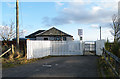
Level Crossing
From the map, you might be forgiven for imagining that this is a vehicular level crossing. Not so; it has been closed to all but pedestrians and presumably riders and cyclists.
Image: © Anne Burgess
Taken: 24 Feb 2012
0.07 miles
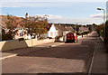
2
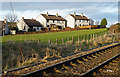
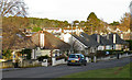
Homes for Trainspotters?
This was taken from the level crossing, one of the few places where it is legal to be on the railway line. These houses have an excellent view of the tracks and would undoubtedly suit train enthusiasts, except that there are rather few trains using this line. Just as well for any occupants who don't happen to like trains, I suppose.
Image: © Anne Burgess
Taken: 24 Feb 2012
0.07 miles
3
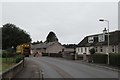
Bin day, Moss-side Road, Nairn
Playing leapfrog with a bin lorry. I had been running more or less the same route since Waverley Road. Now passing Tradespark.
Image: © Richard Webb
Taken: 13 Aug 2018
0.10 miles
4
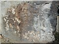
O.S Benchmark
Recorded on Benchmark Database as 'Nairn, Tradespark, Bridge'.
Image: © David Bremner
Taken: 27 Apr 2024
0.11 miles
5
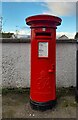
Postbox at Nairn
IV12 23. Royal Mail list this box as 'Lochdhu Post Office'.
Image: © David Bremner
Taken: 20 Nov 2022
0.11 miles
7
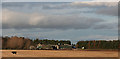
Lochdhu Farm
Looking north across the fields from the minor road.
Image: © Anne Burgess
Taken: 28 Nov 2011
0.19 miles
8
Site of the Tradespark Hall (demolished)
The local community hall was sited close to Sandown Road, Tradespark.
Image: © Ian R Maxwell
Taken: 7 Oct 2006
0.22 miles
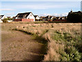
9
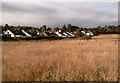
Moss-side Road
This is part of the growing suburb of Tradespark, on the western outskirts of Nairn.
Image: © Anne Burgess
Taken: 24 Feb 2012
0.22 miles
10
Farmland near Wyvis Drive, Tradespark
Image: © Ian R Maxwell
Taken: 7 Oct 2006
0.24 miles