IMAGES TAKEN NEAR TO
Delnies Place, NAIRN, IV12 5EX
Introduction
This page details the photographs taken nearby to Delnies Place, IV12 5EX by members of the Geograph project.
The Geograph project started in 2005 with the aim of publishing, organising and preserving representative images for every square kilometre of Great Britain, Ireland and the Isle of Man.

There are currently over 7.5m images from over14,400 individuals and you can help contribute to the project by visiting https://www.geograph.org.uk
Image Map (Loading...)


Getting Data...Please wait
Leaflet Map data © OpenStreetMap
Images are licensed for reuse under creativecommons.org/licenses/by-sa/2.0
Notes
- Clicking on the map will re-center to the selected point.
- The higher the marker number, the further away the image location is from the centre of the postcode.
Image Listing (14 Images Found)
Images are licensed for reuse under creativecommons.org/licenses/by-sa/2.0
Image
Details
Distance
1
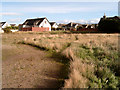
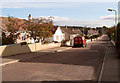
Site of the Tradespark Hall (demolished)
The local community hall was sited close to Sandown Road, Tradespark.
Image: © Ian R Maxwell
Taken: 7 Oct 2006
0.08 miles
2
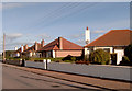
Bungalows on the east side of Sandown Road
Image: © Ian R Maxwell
Taken: 7 Oct 2006
0.09 miles
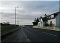
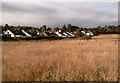
3
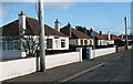
Sandown Road
A row of mid-20th century bungalows on the southern part of Sandown Road.
Image: © Anne Burgess
Taken: 24 Feb 2012
0.10 miles
4
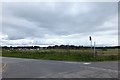
Junction of Sandown Road, Nairn and A96
Image: © Alpin Stewart
Taken: 30 Jul 2016
0.12 miles
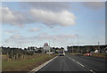
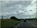
6
The A96 on western outskirts of Nairn
Image: © Douglas Nelson
Taken: 9 Dec 2020
0.14 miles
8
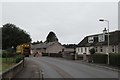
Bin day, Moss-side Road, Nairn
Playing leapfrog with a bin lorry. I had been running more or less the same route since Waverley Road. Now passing Tradespark.
Image: © Richard Webb
Taken: 13 Aug 2018
0.16 miles
10
Farmland near Wyvis Drive, Tradespark
Image: © Ian R Maxwell
Taken: 7 Oct 2006
0.16 miles