IMAGES TAKEN NEAR TO
Mill Road, NAIRN, IV12 5EN
Introduction
This page details the photographs taken nearby to Mill Road, IV12 5EN by members of the Geograph project.
The Geograph project started in 2005 with the aim of publishing, organising and preserving representative images for every square kilometre of Great Britain, Ireland and the Isle of Man.

There are currently over 7.5m images from over14,400 individuals and you can help contribute to the project by visiting https://www.geograph.org.uk
Image Map (Loading...)


Getting Data...Please wait
Leaflet Map data © OpenStreetMap
Images are licensed for reuse under creativecommons.org/licenses/by-sa/2.0
Notes
- Clicking on the map will re-center to the selected point.
- The higher the marker number, the further away the image location is from the centre of the postcode.
Image Listing (41 Images Found)
Images are licensed for reuse under creativecommons.org/licenses/by-sa/2.0
Image
Details
Distance
1
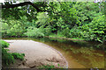
Shingle Bank
The River Nairn has created a small sandy beach on the inside of a bend here.
Image: © Anne Burgess
Taken: 7 Jun 2022
0.05 miles
2
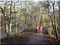
Nairn's Riverside Path
A winter view of this well-used circular walk which follows the River Nairn on the edge of the town.
Image: © Mary and Angus Hogg
Taken: 29 Nov 2013
0.07 miles
3
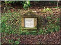
Brooman Well Memorial
Next to the path by the River Nairn
Image: © valenta
Taken: 15 Dec 2016
0.09 miles
4
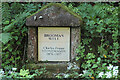
Brooman Well
There seems to be an absence of definite information about how the well got its name. See http://www.gurnnurn.com/2008/08/broomans-or-broomams-well-gets-big.html for some possibilities.
Image: © Anne Burgess
Taken: 7 Jun 2022
0.09 miles
5
Footbridge
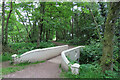
This is a change from the usual type of wooden footbridge on paths. It spans a short drainage ditch from adjacent fields.
Image: © Anne Burgess
Taken: 7 Jun 2022
0.10 miles
6
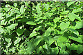
Giant Knotweed (Reynoutria sachalinensis)
Much larger than its familiar cousin, Japanese Knotweed (Reynoutria japonica) which is making such a widespread nuisance of itself. Sadly, it too is invasive, and though not yet so widespread is set to become just as undesirable. It can reach a height of 6 metres.
Image: © Anne Burgess
Taken: 7 Jun 2022
0.13 miles
8
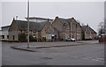
Nairn Town & County Hospital
An NHS Highland community hospital. http://www.nhshighland.scot.nhs.uk/Services/Pages/NairnTownandCountyHospital.aspx
The main building at the front of the hospital dates from 1906, and is a Category C listed building. http://portal.historicenvironment.scot/designation/LB49942
There is a modern extension to the rear.
Image: © Craig Wallace
Taken: 4 Mar 2018
0.14 miles
9
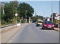
Entrance to Station Park
Home of Nairn County Football Club which plays in the Highland League.
Image: © James Denham
Taken: 1 Sep 2013
0.15 miles
10
Levee and floodplain of the River Nairn
The River Nairn lies on the other side of the embankment (levee) on the left of the photograph.
Image: © Ian R Maxwell
Taken: 8 Oct 2006
0.16 miles