IMAGES TAKEN NEAR TO
Braehead, CROMARTY, IV11 8YQ
Introduction
This page details the photographs taken nearby to Braehead, IV11 8YQ by members of the Geograph project.
The Geograph project started in 2005 with the aim of publishing, organising and preserving representative images for every square kilometre of Great Britain, Ireland and the Isle of Man.

There are currently over 7.5m images from over14,400 individuals and you can help contribute to the project by visiting https://www.geograph.org.uk
Image Map
Images are licensed for reuse under creativecommons.org/licenses/by-sa/2.0
Notes
- Clicking on the map will re-center to the selected point.
- The higher the marker number, the further away the image location is from the centre of the postcode.
Image Listing (521 Images Found)
Images are licensed for reuse under creativecommons.org/licenses/by-sa/2.0
Image
Details
Distance
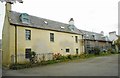
1
Barkly House, Duke Street, Cromarty
Late 18th century, harl and colourwash with slate roof, Listed Category B.
Image: © Alan Murray-Rust
Taken: 19 May 2022
0.00 miles
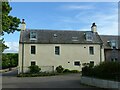
2
Barkly House, Braehead, Cromarty
Category B listed house at the corner of Braehead and Duke Street.
Image: © Richard Sutcliffe
Taken: 18 Sep 2017
0.00 miles
3

Three trees by Braehead, Cromarty
With darkening soon-to-be-rainbearing clouds advancing behind the pale painted houses on Braehead, the three trees on the bank caught my attention as never before.
Image: © Julian Paren
Taken: 1 Mar 2016
0.01 miles
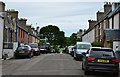
5
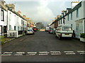
Duke Street, Cromarty
Seen from the junction with Braehead.
Image: © Richard Sutcliffe
Taken: 18 Sep 2017
0.02 miles
6
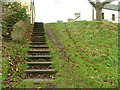
Steps leading to Braehead and Duke Street
From the public park in Cromarty.
Image: © Dave Fergusson
Taken: 22 Nov 2010
0.02 miles
7
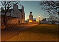
Cromarty Lighthouse
The lighthouse has been decommissioned, and now houses the Aberdeen University Field Station. The lighthouse and keepers cottage date from 1846 and are category A listed.
Reay House on the corner of George Street is early 19th century and category B listed
Image: © valenta
Taken: 22 Jan 2019
0.03 miles
8
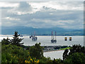
Cromarty from the South Sutor viewpoint
Vegetation has grown up around the viewpoint so that the features identified in the graphic of the panorama are not always visible. From this perspective oil rigs seem to overpower the town of Cromarty visible on the neck of land.
Image: © Julian Paren
Taken: 12 Jul 2015
0.03 miles
9
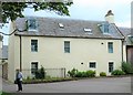
Barkly House, Cromarty
A late 18thC merchant's house in Cromarty and 'B' listed. Hard to believe that the house was in a ruinous state and roofless after a fire circa 1980. Now fully restored and looking splendid.
Image: © Gordon Hatton
Taken: 3 Jul 2019
0.03 miles
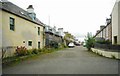
10
Duke Street, Cromarty
Looking east from Bank Street.
Image: © Dave Fergusson
Taken: 22 Nov 2010
0.03 miles