IMAGES TAKEN NEAR TO
Urquhart Court, CROMARTY, IV11 8YD
Introduction
This page details the photographs taken nearby to Urquhart Court, IV11 8YD by members of the Geograph project.
The Geograph project started in 2005 with the aim of publishing, organising and preserving representative images for every square kilometre of Great Britain, Ireland and the Isle of Man.

There are currently over 7.5m images from over14,400 individuals and you can help contribute to the project by visiting https://www.geograph.org.uk
Image Map (Loading...)


Getting Data...Please wait
Leaflet Map data © OpenStreetMap
Images are licensed for reuse under creativecommons.org/licenses/by-sa/2.0
Notes
- Clicking on the map will re-center to the selected point.
- The higher the marker number, the further away the image location is from the centre of the postcode.
Image Listing (177 Images Found)
Images are licensed for reuse under creativecommons.org/licenses/by-sa/2.0
Image
Details
Distance
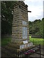
1
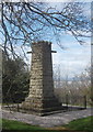
Cromarty War Memorial
C-listed: http://data.historic-scotland.gov.uk/pls/htmldb/f?p=2200:15:0::::BUILDING:23617 .
Image: © Bill Harrison
Taken: 16 Apr 2015
0.11 miles
3
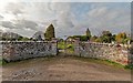
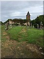
The Gaelic Chapel Cemetery
The Gaelic Chapel Cemetery is also a Commonwealth War Grave Cemetery
Image: © valenta
Taken: 8 Apr 2019
0.12 miles
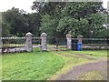

9

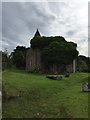
The Gaelic Chapel
A roofless ruin, dating from 1783 and category B listed
Image: © valenta
Taken: 13 Feb 2019
0.13 miles
10

The Gaelic Chapel
In a ruinous state of decay and roofless, the category B listed building dates from 1783
Image: © valenta
Taken: 13 Feb 2019
0.13 miles