IMAGES TAKEN NEAR TO
CROMARTY, IV11 8XT
Introduction
This page details the photographs taken nearby to IV11 8XT by members of the Geograph project.
The Geograph project started in 2005 with the aim of publishing, organising and preserving representative images for every square kilometre of Great Britain, Ireland and the Isle of Man.

There are currently over 7.5m images from over14,400 individuals and you can help contribute to the project by visiting https://www.geograph.org.uk
Image Map (Loading...)


Getting Data...Please wait
Leaflet Map data © OpenStreetMap
Images are licensed for reuse under creativecommons.org/licenses/by-sa/2.0
Notes
- Clicking on the map will re-center to the selected point.
- The higher the marker number, the further away the image location is from the centre of the postcode.
Image Listing (3 Images Found)
Images are licensed for reuse under creativecommons.org/licenses/by-sa/2.0
Image
Details
Distance
3
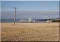
Fields above Cromarty
A harvested field, on the hill above Cromarty. A buzzard is sitting on the electricity pole.
A view across the Cromarty Firth to the Nigg yard, several large wind turbine towers standing by the dock. The cargo ship 'Blue Marlin' is to the right. Image
Image: © Craig Wallace
Taken: 8 Sep 2018
0.20 miles