IMAGES TAKEN NEAR TO
CROMARTY, IV11 8WW
Introduction
This page details the photographs taken nearby to IV11 8WW by members of the Geograph project.
The Geograph project started in 2005 with the aim of publishing, organising and preserving representative images for every square kilometre of Great Britain, Ireland and the Isle of Man.

There are currently over 7.5m images from over14,400 individuals and you can help contribute to the project by visiting https://www.geograph.org.uk
Image Map (Loading...)


Getting Data...Please wait
Leaflet Map data © OpenStreetMap
Images are licensed for reuse under creativecommons.org/licenses/by-sa/2.0
Notes
- Clicking on the map will re-center to the selected point.
- The higher the marker number, the further away the image location is from the centre of the postcode.
Image Listing (5 Images Found)
Images are licensed for reuse under creativecommons.org/licenses/by-sa/2.0
Image
Details
Distance
1
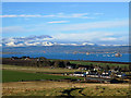
Housing development at Cromarty Mains Farm
The new houses are uphill of Cromarty Mains and have a good outlook over the Cromarty Firth. This view is from the side of Gallow Hill. Ben Wyvis is the major mountain.
Image: © Julian Paren
Taken: 22 Jan 2019
0.03 miles
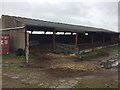
3
Barns at Cromarty Mains Farm
Canmore listing 173660 (https://canmore.org.uk/site/173660/cromarty-defences-fort-south-sutor-cromarty-mains-farm-landward-defences ) describes WW1 era trenches and barbed-wire entanglements in the vicinity of the barn, either for training or coastal defence but nothing is visible on the ground today.
Image: © Bill Harrison
Taken: 21 Apr 2022
0.05 miles
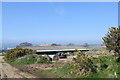
4
At Mains Farm crossroads.
Looking north from Mains Farm above Cromarty. The North Suitor can be seen across the Cromarty Firth.
Image: © Nick Ray
Taken: 12 Jul 2006
0.17 miles
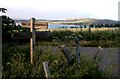
5
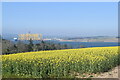
Field corner...
...with the Cromarty Firth in the distance.
Image: © Bill Harrison
Taken: 21 Apr 2022
0.17 miles