IMAGES TAKEN NEAR TO
Long Perry, IPSWICH, IP9 2XD
Introduction
This page details the photographs taken nearby to Long Perry, IP9 2XD by members of the Geograph project.
The Geograph project started in 2005 with the aim of publishing, organising and preserving representative images for every square kilometre of Great Britain, Ireland and the Isle of Man.

There are currently over 7.5m images from over14,400 individuals and you can help contribute to the project by visiting https://www.geograph.org.uk
Image Map
Images are licensed for reuse under creativecommons.org/licenses/by-sa/2.0
Notes
- Clicking on the map will re-center to the selected point.
- The higher the marker number, the further away the image location is from the centre of the postcode.
Image Listing (58 Images Found)
Images are licensed for reuse under creativecommons.org/licenses/by-sa/2.0
Image
Details
Distance
1
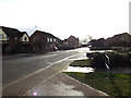
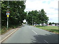
Friars, Capel St.Mary
Looking towards London Road near the playing field
Image: © Geographer
Taken: 5 Feb 2014
0.06 miles
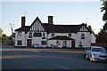
3
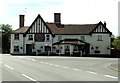
'The White Horse' inn, Capel St. Mary, Suffolk
The main road in this picture, was once the A.12 and this inn must have been a very popular place back then. Parts of the inn date back to the early 18th century, perhaps even earlier.
Image: © Robert Edwards
Taken: 12 Jun 2006
0.08 miles
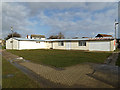
4
By Pass Nurseries, Capel St Mary, Suffolk
Image: © Robert Edwards
Taken: 27 Sep 2006
0.10 miles
5
London Road Capel St. Mary
Looking along London Road Capel St. Mary, Suffolk. This would have been the main route of the A.12 until being bypassed in the 1960s.
Image: © Keith Evans
Taken: 4 Aug 2013
0.10 miles
6
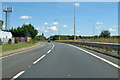
A12 towards Ipswich
Bypassing Capel St Mary which is to the left.
Image: © Robin Webster
Taken: 11 Aug 2018
0.12 miles
8
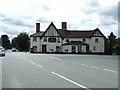
The White Horse
The White Horse public house at Capel St. Mary, Suffolk. The road to the left would have been the main London to Ipswich Road until it was bypassed in the 1960s.
Image: © Keith Evans
Taken: 4 Aug 2013
0.13 miles
9
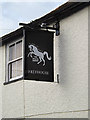
The White Horse Public House sign
On London Road at the junction with The Old Street
http://whatpub.com/pubs/SUF/179/white-horse-capel-st-mary
Image: © Geographer
Taken: 5 Feb 2014
0.13 miles
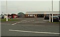
10
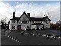
The White Horse Public House, Capel St Mary
On London Road at the junction with The Old Street
http://whatpub.com/pubs/SUF/179/white-horse-capel-st-mary
Image: © Geographer
Taken: 5 Feb 2014
0.13 miles