IMAGES TAKEN NEAR TO
Stutton, IPSWICH, IP9 2SB
Introduction
This page details the photographs taken nearby to IP9 2SB by members of the Geograph project.
The Geograph project started in 2005 with the aim of publishing, organising and preserving representative images for every square kilometre of Great Britain, Ireland and the Isle of Man.

There are currently over 7.5m images from over14,400 individuals and you can help contribute to the project by visiting https://www.geograph.org.uk
Image Map
Images are licensed for reuse under creativecommons.org/licenses/by-sa/2.0
Notes
- Clicking on the map will re-center to the selected point.
- The higher the marker number, the further away the image location is from the centre of the postcode.
Image Listing (22 Images Found)
Images are licensed for reuse under creativecommons.org/licenses/by-sa/2.0
Image
Details
Distance
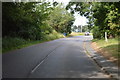
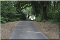
4
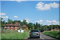
The Drift, Stutton
One of the many narrow lanes in the area.
Image: © Adrian S Pye
Taken: 27 May 2015
0.03 miles
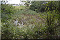
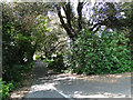
8
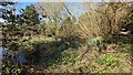
Small pond next to the road
Probably the site of a quarry
Image: © Sandy Gerrard
Taken: 17 Apr 2023
0.06 miles